
|

|

|
|
06/27/06. Boedecker Reservoir near Loveland. A nice paddling evening. Interesting clouds over the mountains. A distant rainbow, but too weak to photograph it without a polarizer filter. The water level was about 3′ lower than six weeks ago. Some islands were not islands any more. One fishing boat and two canoes. I paddled my old CLC Patuxent 19.5 kayak. It is already 7 years old! After installing a new seat (bumfortable seat from Steve Gurney as in my Sisson), the Patuxent is much more fun to paddle. I even tried to paddle 1000 m sprint for the virtual race. I started with a good speed around 6.8 mph but after a minute or so I started to wheeze and needed to slow down. I found a good spot on lake to photograph Devil’s Backbone (the third picture). I need to return back with my SLR camera and a telephoto lens. All pictures above were shot with Pentax Optio W10. Related posts: |
||
Author: Marek
-
CLC Patuxent 19.5 Kayak on the Boedecker Reservoir
-
Paddling Kayak and Canoe in Northern Colorado
I have been living at Fort Collins in northern Colorado for 17 years. Before 1999 I had only a folding kayak, Feathercraft K1 expedition, and didn’t paddle very often at least according to my today standards.
 Nevertheless, in addition to my local Horsetooth Reservoir, I visited several mountain lakes including Dillon, Turquois and Granby. In 1999 I built stitch-and-glue kayak, CLC Patuxent 19.5, and started a real exploration of Colorado waters. At the same time my garage started to convert into a boathouse …
All this time I have been recording my paddling trips with a camera and later with a GPS. I have started to post my photo reports at Mountain Wayfarer web page. I am always exploring new ways to present this information on-line. Today, my paddling resources are spread over several web pages. It may be useful to provide a short summary what is available and some information on ongoing projects.
1.
Paddling destinations at Mountain Wayfarer site. This is the original site with my paddling reports.2.
A map of paddling destinations using Google maps API (application software interface). This is the ongoing project. Each destination marker can be opened for a picture that is linked to a paddling destination at Mountain Wayfarer or to a related blog entry.3.
River guides. These are more detailed river descriptions with GPS tracks, mileage and and maps prepared as a result of numerous day trips. Most often these were upstream/downstream trip in my Sisson Nucleus kayak.So far, I have covered the Poudre River from Laporte to Greeley and a few miles of Big Thompson River below Loveland. I have gathered all information to prepare a similar description of South Platte River from its confluence with St Vrain River to Cooper Bridge below Fort Morgan.
Eventually, I am planning to upgrade all maps in those pages to Google maps similar to the coverage of Dismal River.
4.
Wayfarer trip index. It covers blog entries from from recent trips and paddling workouts.5.
Paddling Colorado – links to Colorado paddling resources including books. They have not been updated for while.6.
Weather and water . The river flow information is essential to planning any paddling in Colorado.7.
Finally, my video clips illustrate some of our local waters: Boyd Lake, Horsetooth Reservoir, Beaver Pond, Poudre, South Platte and Colorado Rivers.
-
30+ Miles of South Platte River in Eastern Colorado
My original plan was to paddle nearly 40 miles of South Platte from Orchard to Cooper Bridge. I wanted to resume my February low water paddling Masters to Orchard and explore another segment of the river. In winter, I also paddled the last few miles of my course: from Cooper bridge upstream to Snyder and back. Connie agreed to provide a shuttle. She was accompanied by my mother visiting us from Poland.
First troubles appeared at the Orchard bridge when preparing my safari boat (Spencer X-treme canoe) for launching. A local farmer asked me not to disturb duck and goose nesting area by paddling the river below Orchard. It seemed that he put two fences across the river to protect the area. After some discussion I agreed to move my launching 4 miles downstream to the next bridge at Goodrich. He wasn’t aware if I would encounter similar problems further downstream.
So, I started at Goodrich. The water level wasn’t high but adequate for paddling. I had to search for deep water channel but I could travel down river close to 7 mph.

After 3 miles I reached the first diversion dam: Fort Morgan Canal. I landed about two hundred yards upstream on the left shore to avoid a concrete rubble near the dam. I didn’t paddle very far below the dam before I found another lower dam. A double portage!


The river was full of wildlife. Ducks, geese, pelicans, bald eagles, kingfishers, a lonely turkey male. I had several meetings with whitetail deer: usually couples or small herds on shores, on islands, or crossing the river. I had to follow deeper water sometimes very close to a shore. A surprised beaver almost jumped from the bank to my boat. It was closer than the length of my paddle. Sunbathing turtles were sliding to water when I was approaching. And, finally, I had a close meeting with a water snake at the landing above the second dam. I believe it was a northern water snake often mistaken for a water moccasins, 3-4′, dark gray. It swam away.


The second diversion dam, Upper Platte and Beaver Canal, was quite impressive: very tall three segments with a total length probably more than 400 yards. I didn’t expect to see such a wide dam on the South Platte. I portaged on left. There were some natural and concrete rocks in water below the dam creating even small rapids. I found concrete pieces from the dam as far downstream as a quarter of mile. It looked like the dam was broken in the past. The river got significantly shallower and my pace slower.


The third diversion dam (Lower Platte and Beaver Canal) was just above Dodd Bridge where I had a meeting with Connie and my mother. The river got even more shallow. More and more often I had to drag my boat over sand and gravel bars. My speed dropped down to 4-4.5 mph. I decided to finish my trip at next bridge near Snyder in order to go at reasonable time for a dinner at Fort Morgan’s Memories (now closed).
The most scenic part of the river was above Fort Morgan. I often paddled along very narrow and twisty channels. Road bridges and State Wilderness Areas provide numerous access points to the river. It doesn’t meant that launching kayak or canoe is convenient. Usually, launching at bridges requires crawling under barbed wire fences. I still need to paddle four miles from Orchards to Goodrich to have the full coverage of South Platte from St. Vrain Creek to Cooper Bridge. So far, I haven’t seen water flow that would allow me to paddle below the Cooper Bridge.
I was shooting pictures with my Pentax Optio WP camera, however, the light during the day despite of some clouds was pretty harsh and colors came quite washed out.
Approximate river mileage: 3.0 – Fort Morgan Canal Dam, 6.8 mile – County Road 9 bridge near Weldona, 8.9- Colorado Highway 144 bridge, 15.1 – Upper Platte and Beaver Canal Dam, 17.4 – Colorado Highway 52 at Fort Morgan., 23.4 – Lower Platte and Beaver Canal Dam, 23.8 – Dodd Bridge on county road 24, 31.0 – Colorado Highway 71 bridge near Snyder.
GPS trip odometer: 31.2 miles, moving time 5:59h, stopping time 1:17h, moving speed 5.2 mph, max speed 8.5 mph. River flow: Weldona ~400cfs, Ft. Morgan ~380cfs, Cooper Bridge ~180cfs.
Related posts and resources:
South Platte River below Denver, Colorado GPS/photo river guide
Paddling on Wet Sand: Discovering the South Platte River in Eastern Colorado
Paddling on Wet Sand: the South Platte River below Fort Morgan
Paddling under the Rainbow Bridge – Fort Morgan, Colorado -
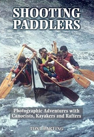
Shooting Paddlers – Photographic Adventures with Canoeists, Kayakers and Rafters

Shooting Paddlers: Photographic Adventures with Canoeists, Kayakers and Rafters, book by Toni Harting, a Canadian outdoor photographer, writer and canoeist. 212 pages. Cardinal Publisher’s Group, 2004.
Toni Harting migrated to Canada from the Netherlands in 1970 and has lived in Toronto with his wife and canoeing partner, Ria, ever since. He holds two Master of Applied Science degrees in aerospace engineering, but left his consulting engineering profession in 1974 to build a new career as full time freelance photographer specializing in canoe topics, particularly wilderness canoeing.
You can learn a lot from his book. It is designed to help all paddlers strengthen their ability to see, recognize and record meaningful images. At the same time the book is simply fun to read or browse through it.
There are more than two hundred black and white and color pictures. Some of them are in two versions, e.g. an original picture and the same picture after cropping. Each picture is accompanied by its story and discussion with tips on composition, technique and logistics. Of course, there is also a chapter on equipment but you will not find information on a highly specialized gear, rather tips on using regular 35 mm point-and-shoot and SRL cameras.
There are many amazing shots. You can see a lot of action pictures from canoe and kayak racing and rafting, contemplative scenic or close up shots, pictures from paddler’s life on camping or portage trail. You will not find many pictures from sea kayaking, but a great representation of a canoe including sprint and marathon canoes, voyageur canoes and dragon boats.
My picture of a paddle in my another weblog entry was inspired by one of Toni Harting photos. I just need to work more on that shot… And, I got some more photo ideas from his book.
I always admire people who have sacrificed their “other” career to be a full time photographer. I know enough about photography to recognize how hard photographer job is and that it is not only about shooting pictures. Writing skills help for sure.
Outdoor and action adventure photography books:
/>
Related posts and links:
-
Paddling Sisson Nucleus on South Platte River above Evans
 A nice sunny weather and a good river flow. This time I launched my Sisson Nucleus in the afternoon at Evans River Park and paddled upstream to take a closer look at the portage over Latham Ditch Dam near La Salle. After a mile of upstream paddling I stopped under railroad bridge to take some documentary photos of an old palisade blocking passage and gathering logs and other junk. These pictures will go to my S. Platte River paddler guide. So far, I have covered about 50 continuous miles of the river from St. Vrain Creek to Masters.
The river below the dam had very little flow and was very shallow. Most of the water went right through a channel with steep banks closed by three gates. I paddled the shallow river to about 200 yards below the dam where I got finally stacked in sand. At that water level the portage was not difficult despite of some huge logs blocking access to the river. However, at higher water with flow over the dam, the landing there would be much more difficult.
I paddled about 3 miles upstream and turned around at sunset after shooting a couple of pictures. In my return way I choose different route around the dam. I paddled into channel and took off on a very steep shore between gates. Very uncomfortable at least in my tippy kayak, requiring some strength from a solo paddler, but obviously possible. It sounds like a good safari training. I did the same portage with my Spencer X-treme canoe during my birthday run down St Vrain Creek and South Platte river to Evans in April.
I finished at Evans shortly after sunset with a thin layer of ice forming on a deck of my kayak. It was nice to be able to change into dry cloths and have a cup of hot tea before driving home.
GPS trip odometer: 5.92 miles, moving time 1:49 h stopped time: 0:39 h, moving average 3.3 mph, max speed 8.5 mph. Average HRM: 131. River flow: S. Platte @ Kersey: ~850cfs. Air temperature 42-35F.
