Category: trip reports

reports, river guides, maps, GPS tracks

  • Paddling through Forest and Irrigation Ditches

    Paddling through Forest and Irrigation Ditches


    Lonetree Reservoir southwest of Loveland belongs to my favorite paddling waters in northern Colorado. You can always enjoy a nice view of Rocky Mountains Front Range. It is a great spot to shoot sunsets over mountains:
    A Peaceful Sunset after a Heavy Gun Fire on the Lonetree Reservoir
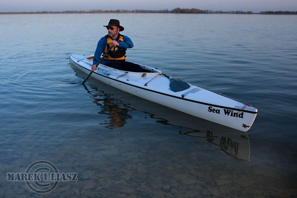
    5 Pictures in 1: HDR Image of Sea Wind Canoe and Colorado Sunset
    Sunset Is Not Always Spectacular over the Front Range of Rocky Mountains
    3 Pictures from Sunset Paddling in Northern Colorado


    However, in springtime when reservoir is full it’s time to explore some hidden treasures – submerged cottonwood forest in different lake corners. Please note that the heron rookery is a restricted area.


    During last few weeks I paddled different boats on the Lonetree Reservoir: Surfrigger (outrigger canoe), Thunderbolt-X kayak, and Sea Wind Canoe. I cannot take Surgrigger into tight passages between cottonwood trees.


    There is a lot of floating debris after recent heavy rains. So, Sea Wind is the best choice for my exploration.


    7 years ago I was training here with Spencer X-treme canoe for my first Texas Water Safari. I couldn’t find any other place in my vicinity to practice portaging over fallen trees and log jams.


    At this high water level you can even escape the lake and explore some irrigation channels.


    You can easily find the inlet of a supporting channel to the lake. It is a little water cascade over headgates when the lake is low, but at this time it was the same water level in the reservoir and channel. However, there is also another entry to that channel hidden in woods which I discovered this year. No portage.

    Paddling away from the lake across farmland. Deep water, big fish, water foul.

    How far can I go? County road 14 bridge.

    About 0.5 mile from the lake – another headgate and my turning point

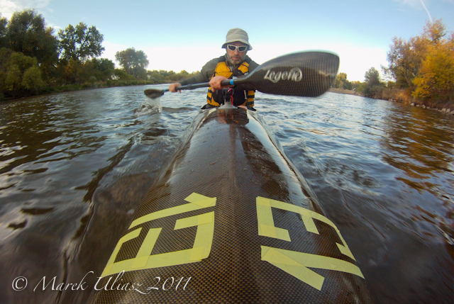
    All pictures from a boat were shot with Pentax Optio W30 camera. They turned pretty good, especially, during the last paddling with overcast and a drizzle or rain. Paddling selfportraits were shot with Canon EOS D40 DSLR camera on a tripod with aid of the programmable self timer.


    Returning back to the lake.


  • Group Paddling Workout on the South Platte River

    Sunday afternoon, February 15, 2009. 2×5 mile paddling workout on the South Platte River: upstream from Kersey to the Plumb Ditch dam and back down the river, about 3 hours with some playing and shooting at the dam.  Flow at Kersey: ~500cfs.

    Four solo kayakers: Jeremy in a wildwater racer, Rob in Spencer X-treme canoe, John in Ruahine Opus, and me in Thunderbolt-X kayak.

    Cameras: Pentax Optio W30 (pictures from a kayak) and Canon EOS 40D with EFS 17-55mm zoom lens (pictures at the dam).

    South Platte River below Denver – GPS/photo river guide

    Returning Back to (Paddling) Life

    Old Truck, Young Eagle and the South Platte River Mysteries

    Paddling Thunderbolt Kayak in Tight Places – Lone Tree Creek

    Kayaking on Saint Vrain and South Platte Rivers near Platteville

    South Platte River – Another View or How to Photograph the River?


  • Winter Paddling in Colorado: the South Platte River Near Kuner

    Another afternoon paddling on the South Platte River, this time near Kuner. It was warm, but windy. I packed again my DSLR camera with a tripod into Thunderbolt kayak, but didn’t have an opportunity to shoot to many pictures. The light wasn’t that great. So, all pictures below come from Pentax Optio W30, except the last one of old cars.

    I have several favorite “tight places” on the South Platte. One of them is a narrow channel a mile or so upstream of Kuner. The river forms a pretty big island there.

    There was enough water in the channel for careful paddling upstream, but in the middle I was stopped by a log jam.

    Paddling down the river under highway 37 bridge at Kuner. The landing spot in nowadays on the right shore behind the bridge pillar. Paddling downstream you will see first another bridge (further east on hwy 37) on a smaller river arm. Years ago I used to land there until the place was tightly fenced.

    I paddled further downstream to the Empire Reservoir dam hoping to shoot some pictures. It used to be a quite photogenic old style dam with a footbridge across the entire river. The dam was rebuilt recently and made taller. It will be not difficult to portage it on right, but right now it’s a mess with a loose sand where you can sink above your knees. I believe that they started to divert water to another reservoir here. Anyway, more than half river is going away.

    I finished my paddling with shooting some old cars on the river shore.

    South Platte River below Denver – GPS/photo river guide

    Returning Back to (Paddling) Life

    Old Truck, Young Eagle and the South Platte River Mysteries

    Paddling Thunderbolt Kayak in Tight Places – Lone Tree Creek

    Kayaking on Saint Vrain and South Platte Rivers near Platteville

    South Platte River – Another View or How to Photograph the River?


  • 3 Winter Paddling Hours on the South Platte River

    3 Winter Paddling Hours on the South Platte River

    My local paddling lakes are frozen, but Horsetooth Reservoir is still open and the South Platter River is flowing. Unfortunately, I am not ready for my usual winter paddling yet. I need a few weeks to recover from my wrist surgery which I had just before Christmas.

    Meantime, I am reposting a photo story from my paddling on the South Platte River on January 12, 2008. I paddled Thuderbolt-x kayak upstream from Kersey to the Plumb Ditch Dam and back down the river. All pictures were shot with Pentax Optio W30.

    Rob Bean just paddled the same course on the South Platte with his Spencer X-treme canoe and a new wing paddle. He posted some pictures from this trip on Facebook.

    South Platte River

    14:00. I am launching my Thunderbolt kayak under the bridge at Kersey and starting to paddle upstream. Air temperature: a few degrees above freezing. Partially cloudy. River flow: 480 cfs. Snow on the ground and a little bit of ice along shores.

    There were some spectacular icicles a year ago on this shore. I have a tendency to shoot pictures at the same spots.

    South Platte River

    Passing old cars above Kersey. It is the same “parking lot” where in October 2007 I had a close meeting and a photo session with a young eagle.

    The river has developed some new channels during last year.

    South Platte River

    1 minute stop at the mouth of Lone Tree Creek. This time, the water level is too low to go any further. Perhaps, 50 geese were sitting there just a few seconds ago. No hunters.

    You wouldn’t notice this creek when paddling downstream. Paddling upstream reveals many river secrets.

    South Platte River

    Working hard upstream. Speed between 2 and 3 mph. 1 hour to confluence with the Cache la Poudre River. As expected there were some goose hunters there just packing their decoys.

    Mitani-Tokuyasu State Wilderness Area next to the Poudre used to be my favorite spot for kayak launching. However, nowadays, this area is open only during hunting season and a parking space is limited to 4 cars. Also, all trees on this shore died for some reason during last couple of years.

    South Platte River

    I believe that the South Platte is getting somewhat faster with more shallow spots above the confluence with the Poudre.

    Plumb Ditch Dam – the target of my upstream workout today. Two hours, almost 5 miles.

    I heard hunters somewhere near the dam, so I turned around and landed on a gravel bar a little bit further downstream.

    10 minute stop. A cup of hot tea. And, easy paddling down the river back to Kersey.

    South Platte River

    Sunset. Beautiful light, but is getting cold. Brrrr!

    My speed down river varies between 6 and 8 mph. Of course, I am tired after upstream workout, however, I am hitting shallows more than when going slowly upstream.

    South Platte River

    Eagle tree. There were 6 bald eagles sitting on that tree. I saw many more eagles along the river.

    South Platte River

    16:50. A few minutes after sunset. I can hear the Kersey bridge.

    There is always a heavy and fast traffic on this road even on weekends. So, be careful during your launching operations.

    9.7 miles paddled during this trip according to my GPS.

    Related posts:
    South Platte River below Denver, Colorado – GPS/photo river guide
    Paddling with Icicles – Thunderbolt-X on the South Platte River below Greeley
    Old Truck, Young Eagle and the South Platte River Mysteries
    Paddling Thunderbolt Kayak in Tight Places – Lone Tree Creek
    January 2001 – My First Paddling on the South Platte River

  • Paddling in Fog on the Lower Suwannee River

    Fog on a river may be really photogenic. Well, if it is not too dense. I rarely have occasion to paddle in fog in a dry Colorado and when it happens it is usually too cold to enjoy it.

    I just returned back to my pictures shot im March of 2006 during the WaterTribe Ultimate Florida Challenge. I didn’t complete that race around Florida. However, after quitting the official race and some rest I paddled across Florida from Fort Clinch to Cedar Key.


    My last two nights on the Suwannee River were really cold. I believe the air temperature was dropping down to 30s. A dense fog was forming over the river making night paddling somewhat challenging. However, mornings with rising sun were beautiful and provided me with many photographic opportunities.

    The above pictures were shot with Pentax Optio WP in a fully automatic mode but usually with some adjustments of exposure time. I have assigned EV compensation to the “green button”. Right now, the exposure compensation in my Pentax is at the first position available by one click to the green button. I am often underexposing when shooting in the harsh light of the middle of day as well as during sunset or dusk shooting. You can see that the image quality at low light was pretty poor from my Pentax Optio WP, but that compact and waterproof camera was easily accessible all time.


    Florida kayak canoe

    SandyBottom aka Dawn Stewart described the foggy nights on the Suwannee at the 6th position of her Scariest Moments during the Challenge.

    6 – The fog (and dark and cold) on the Suwannee River, 3 nights in a row. There are often trees down and branches overhanging on the banks of the River creating what could be a very dangerous situation. There was also no moon the nights we were on the Rivers, it was very dark. Three nights in a row, on the Suwannee, in the pitch dark, the fog was so thick, that we often couldn’t even see the outline of the tree line. Even more frightening because there were constant turns on the River, sometimes as often as every 50 yds. These nights were also some of the coldest, with lows in the 30s. One night the fog was so bad, that DrKayak, RiverJohn, and I had to raft up and float, knowing we were going in the right direction because of the current, but worried if we hit a bank, we needed to be together, in case there was trouble.

    I don’t remember those nights as scary, however, I experienced fog at the lower more open river than SandyBottom’s group. I had also a reference to my paddling in 2003 Texas Water Safari.

    There was a dense fog at night over Guadelupe River between Dupont and Salt Water Barrier. I could see only tree tops and nothing on the water surface. I was really scared that hitting something would result in capsizing my tippy safari canoe in a gator territory. Fortunately, I didn’t hit anything in the fog. Later that night when the fog cleared, I hit a submerged log in the middle of the river below Tivoli but I didn’t capsized.

    By comparison, I felt pretty safe on the Suwannee River in my stable Sea Wind canoe. I suppose I am more a river paddler than sea kayaker. I was much less comfortable when entering the Gordon Pass during night with some choppy water condition.

    Related posts in fitness paddling blog:


  • My First Paddling on the South Platte River near Greeley

    I discovered the South Platte River for paddling almost 8 years ago in January 2001. I believe it was the first river I paddled in northern Colorado and, for sure, my first winter paddling here. Here is some old writing on these day trips with my CLC Patuxent 10.5 kayak. It was originally posted on Mountain Wayfarer site. At that time, I was shooting slides with Canon EOS 2AE SLR camera.

    I was launching my kayak at Mitani-Tokuyasu State Wilderness Area just below the mouth of the Cache la Poudre River. This place is less suitable for paddling now days. It is open only during a hunting season and closes by the end of February. A parking space is limited to 4 cars only. See my GPS/photo river guide for other access points.

    South Platte River

    January 21st, 2001. A cold afternoon with snow clouds over entire Colorado, the last glimpse of sun. The winter of 2000/2001 is pretty cold; all my paddling lakes are frozen. The only open water I can find is the South Platte River.

    South Platte River

    I am launching my kayak at Mitani-Tokuyasu State Wilderness Area (SWA) located below Greeley, where the Cache La Poudre River joins the South Platte. This place can be reached from Highway 263 (east of Greeley) by a short stretch of bumpy road.

    I’ve also explored another possible launching place: the Brower SWA, a few miles upstream – a little more difficult access to the river.

    South Platte River The flow is about 700 cfs and the river is shallow in wider places. The Cache La Poudre doesn’t add much water in winter, only about 70 cfs.

    I am paddling upstream against a pretty strong current. A little bit of snow turns this so-so river into a scenic waterway. Despite the nearby civilization and hunters, I see many birds: geese, ducks, eagles and a flock of 20-30 wild turkeys.

    South Platte River After about an hour and a half of paddling and perhaps 3 miles I am reaching my turning point:
    a diversion dam above the 58th county road bridge. Plumb Ditch?
    South Platte River

    Resting on a small island just below the dam. Hot tea. It’s getting dark and starting to snow again. Snowflakes stick to the lens of my camera, and ice
    covers the kayak deck.

    South Platte River Paddling against wind and snow, but down the river. It takes only 25 minutes to reach my launching spot.

    Paddling in a snowstorm is much more pleasant than driving in it.


    It was my second kayak trip on the South Platte River. The first one took place a week earlier.
    Winter conditions but no snow. I explored the river upstream and downstream of the launching place, as well as a short stretch of Cache La Poudre River.

    The third trip: February 11, 2001. The same route as before upstream to the diversion dam and back. Snow but sunny. A lot of hunters and shooting around but getting quiet at sunset.
    I met the same turkey flock resting on a sandbar.


    Related posts:

    South Platte River below Denver, Colorado – GPS/photo river guide

    Winter Dusk on the South Platte River

    Winter Afternoon on South Platte River with Thunderbolt-X Kayak

    Winter Canoeing on the South Platte River in Northern Colorado

    Climbing Snowdrifts on the South Platte River with Thunderbolt Kayak

    Paddling during Duck and Goose Hunting Season on South Platte River?


    .


  • Dangerous Rapids on South Platte River 50 Miles below Denver… Where is Deer Island ?

    This post was originally published in my old Wayfarer blog on November 19, 2005. I am starting to think about winter paddling season on the South Platte River.

    Eight o’clock the next morning found us moving onward toward Deer Island, which we soon reached. Here, for the space of two miles, the water seemed to have a greater fall, and a far more rapid current, than at Denver. Having heard so many stories regarding the dangers at this place, which had wrecked all former expeditions of a similar nature, we naturally approached the spot with a feeling of awe mingled with the gravest doubts. Every man remained at his post with that determination of purpose that is reached only under the most desperate circumstances.

    As we entered the channel the angry waves seized our little craft and sent it forward at a greatly increased rate of speed, as if they would dash it to pieces. This increased our alarm, but not a word was spoken, as the foaming, surging waters carried us onward, except an occasional command from the bow. With Jackson at the rudder, Matthews at the “lookout,” and Smith and myself alternating at the oars, we held the Rover to the channel and dodged the snags with great precision. Thus, by dint of the most most persevering efforts, we steered clear of all dangers, though nearly exhausted, and glided out upon the comparatively clam waters of the Platte beyond.

    About three years previous, two disheartened miners, while attempting the voyage between Denver and the Missouri, had been wrecked at his point; the body of one being washed ashore just below the island, where it was found by herders, portions of the canoe were also found later, but further down the stream.

    This was an excerpt from “A thousand miles in a canoe: Or, A canoe voyage from Denver, Colorado, to Leavenworth, Kansas during the summer of 1867”, a book written by Dean Perceval and published in 1880. I’ve found the book, I was asking about a couple of weeks ago. I’ve got it on a microfilm through interlibrary loan and scanned all pages. I will be writing more about that voyage.

    Where is that Deer Island? According to the book: “Deer Island, some fifty or sixty miles below Denver”. According to my GPS software it could be somewhere between Evans and Kersey, so in the river stretch used for a popular easy club paddling trip in early spring. And, it is where I paddle during winter season .

    Of course, they didn’t have GPS, so some fifty or sixty miles may be not very accurate. Nevertheless, it would be difficult to find today such an interesting river segment between Denver and Fort Morgan. The river could look somewhat different without a diversion dam every few miles. I should add that the 1867 trip took place in June at high water after heavy snowstorm.

    So, has anybody heard about Deer Island somewhere in the Weld County? On some maps you can still find a mysterious name of Scout Island at the confluence of Cache la Poudre and South Platte Rivers, but it must be a different story.


    Some resources on paddling the South Platte:

  • The Last Frame during the 2008 Missouri River 340 Race

    I packed my Canon EOS 40D camera with a tripod for the recent MR340 race. I launched 40 minutes before the start and paddled across the Kaw River to shoot 150 boats lining up above boat ramp, then starting, entering the Missouri and heading down the river.

    Exactly speaking, there were only 149 boats starting since my Sea Wind canoe was waiting for me stacked in a muddy beach of the Kaw River. Amazingly, I lost not more than 5 minutes to other boats before I was able to launch and start my race. You can see 8 of these pictures in the Fitness Paddling blog.

    After 86 miles and more than 12 hours of almost non stop paddling (just a few minute breaks at two checkpoints) it was time to stop and turn my navigational lights on. Fortunately, the Big Muddy offered a beautiful big sandbar for this purpose. I couldn’t resist the quiet sunset and unpacked my camera and tripod. I spend next 25 minutes shooting. I preferred not to count how many boats passed me during that time.

    The above picture is a HDR image derived from three 3 frames shot with different exposure time, processed and map toned with the Photomatix software. It is similar to my recent picture of the Colorado sunset combined from 5 frames.

    During the 2007 MR340 I also stopped to shoot sunset between Waverly and Miami, but I was about 10 miles closer to Miami paddling a faster Thunderbolt kayak. Mark Przedwojewski and Brian Weber were just passing in their Kruger cruiser. At that time Connie was at Miami looking upstream and shot a picture of West Hansen and Richard Steppe approaching the checkpoint.

    This year I managed to shoot Toby is his Sea Wind leaving the sandbar. Why he was in such a hurry?

    It was the last time I used Canon camera during the race. My serious photography attempts ended there. The camera and tripod remained packed till Coopers Landing where I left them with my wife. I focused on paddling and shooting with my compact Pentax Optio W30.


  • Paddling Workout with a Dog – Pixel First Time in Sea Wind Canoe

    Yesterday, Pixel, my Corgi puppy has his debut as a paddler. We paddled 10 miles in Sea Wind canoe on Beaver Pond in Arapaho Bend Natural Area near Fort Collins. He behaved perfectly in the front of Sea Wind cockpit. It is much easier to paddle with a little Corgi than with Dax, our 100+ lb Newfoundland.

    Pictures were taken with Pentax Optio W30 camera. I think we have more photographic opportunities here.

    paddling with a dog

    paddling with a dog

    paddling Colorado

    Related posts and links:
    Paddling with Pixel, the Water Corgi
    Stand Up Paddling with Pixel, the Water Corgi