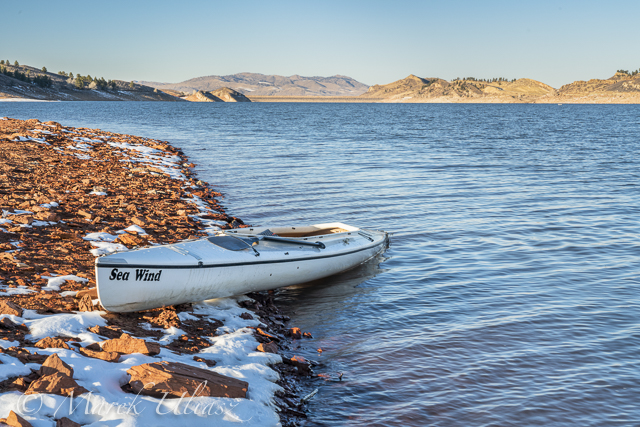
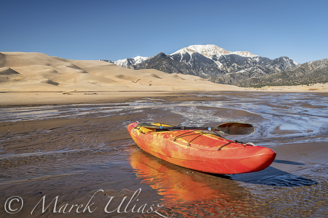
New Year Day afternoon. I started the 2021 paddling on Horsetooth Reservoir with Sea Wind, my expedition canoe. No drysuit or wetsuit needed, but loading this boat on Toyota 4Runner and carrying to water was a good crossfit training in comparison to paddleboards. It wasn’t a long trip, just 6 miles with a longer break for photography.
This boat is almost 20 years old. I bought my Sea Wind, #127, from Verlen Kruger in Michigan in 2001. Actually, it was the first canoe built by Mark Przedwojewski aka ManitouCruiser, then the new owner of Kruger Canoes. It’s all history now …
Horsetooth Reservoir is pretty low at 46% of its capacity. Last winter is was almost full. A very different scenery and paddling conditions. Water temperature is still 49F and no ice cover. See: current Horsetooth Reservoir conditions.
Satanka Cove at northern end of the lake is the best place to start paddling. I usually launch my boats just next to the Horsetooth Dam. It is steep, but the shortest walk to the water from a parking lot. At low water level, the boat ramp (closed) at Satanka Cove is very long. You can also launch from Lory State Park at Soldier or Eltuck Cove, but again it’s a very long walk under current conditions.
It looks like during last few years I was able to paddle Horsetooth Reservoir almost all winters. The effect of a global warming? I remember that 10-20 years ago I was doing most of my winter paddling and training on the South Platte River with an occasional trip to Lake Pueblo.
I love paddling on the Horsetooth Reservoir in cold season. Boat ramps are closed, no power boat traffic, usually quiet and calm. Snow and ice can enhance scenery. A great time to paddle, train, relax or photograph.
The Horsetooth stays ice free longer than Boyd Lake or smaller lakes in Fort Collins like Beaver Pond in Arapaho Bend Natural Area. South Bay freezes first, and than smaller coves. Don’t get discouraged by a webcam showing the South Bay. Very often you can still find open water in northern end of the reservoir at Satanka Cove.
In some years, I was able to paddle Horsetooth for the entire winter, in others till February. This winter season is somewhat unusual because water level is very high.
Earlier in a cold season I am using a wet suit, and later I am switching to supskin drysuit. I always paddle in life jacket and safety leash on paddleboards. I also carry the spot device for emergency, and always some sort of photo equipment.
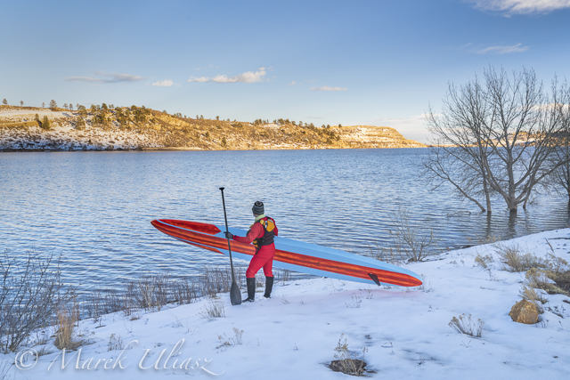
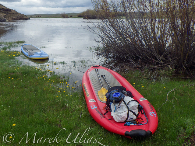
This winter I am paddling mostly various stand up paddleboards and sometimes my expedition canoe.
Here are some pictures and comments from my paddling in 2019/2020 season. What is your experience from paddling Horsetooth Reservoir in winter? Any practical tips?
Horsetooth Reservoir in February 2020 as seen from a parking lot at Satanka Cove. A tip of that peninsula is a good place to launch when the cove is covered by ice. You can also take a shorter, but steeper walk towards the end of Horsetooth Dam.A few time in late fall I launched my paddleboards from the Lory State Park at Soldier Cove. It’s a pretty short walk (~200 steps) to water protected from winds. Of course, later in winter is not an option. The picture above shows my last launch of 14’X26″ All Star by Starboard SUP there on January 12. It involved some walks around ice fields.
Occasionally, I am taking a walk between Satanka and North Eltuck Cove, just for fun and photography. Let’s call it cross training.A thermos bottle with hot tea belongs to my standard equipment in winter paddling, since I often take longer breaks for photography. Usually, it happen close to sunset when it’s getting pretty chilly.Experimenting with a low angle POV from a partially submerged action camera – Sony RX0 2. That camera has a narrower angle of view than GoPro and it doesn’t work so well as a bow camera on a 14′ paddleboard. A longer board needed!
Satanka Cove. First paddling in a snow blizzard. A great opportunity for photography.
Paddling along icy cliff in Sea Wind, a heavy duty expedition canoe designed and build by legendary Verlen Kruger. This boat is a great icebreaker, but it’s much easier and faster to load SUP on roof racks.
February 15. Northern part of the lake was still open. Trying a new board in icy conditions: 17.6’x24″ Mistral Interceptor. I needed something to much my Santa drysuit
The long, unlimited paddleboard (~35 lb) is more awkward to carry around than 14′ boards. And, even a safety leash attached makes it tail heavy.
Late March on Beaver Pond in Arapaho Bend Natural Area near Fort Collins. The lake was ice free for about two weeks. No green colors yet. Geese are still swimming, but starting to settle down on two islands. Muskrats are showing up near shores. I was visiting this area in winter time as well, but with my fat bike.
2018 model of 14×26 All Star SUP by Starboard.
It is where my last winter time on water, and then my first spring paddling took place. I was testing my new stand up paddleboard: 2018 14×26 All Star by Starboard in carbon sandwich layout. I’ve ordered it from Paddle Surf Warehouse in California – a great customer service, free shipping, a bag and a custom cut VESL paddle was included. The paddleboard was ordered on Monday and arrived in a good shape to my home on Friday.
2014 14×28 All Star stand up paddleboard
It is my second All Star SUP. The first one, 2014 model 14×28, I got in the fall of 2016. I used it for paddling workouts on my local lakes and rivers (with a pivoting fin), and for a few long distance river races in 2017: South Dakota Kayak Challenge, Fort to Field 50 on the Missouri River, and 31 mile Chattajack. 2017 MR340 race I paddled a heavy expedition board.
Racing plans for 2018 All Star SUP? Some shorter river marathons including Chattajack. I am not sure about MR340 yet. Maybe, I will have to sit down …
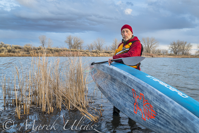
A photo session with the Starboard SUP
I don’t dress for immersion when paddling the Beaver Pond (or the shallow South Platte River). However, I am staying close to the shore at this time of year. I paddled Horsetooth Reservoir in winter, but always in Supskin drysuit. A photo session with the Starboard SUP
All pictures were shot with the mirrorless Sony A7R2 camera with Sony 24-70mm lens. The camera is mounted on a light Gitzo Mountaineer Tripod. This is my minimalist camera set for paddling, biking or hiking. I usually carry the camera in Ortlieb Aqua Waterproof Camera Bag. That bag can hold a DSLR camera with a zoom lens, so it is a little bit too large for my mirrorless Sony. I can add a small tabletop tripod to the bag.
A photo session with the Starboard SUP
Selfies were shot using time-lapse application on the Sony camera. Unfortunately, this approach requires sorting through hundreds of images. There is no need for an external intervalometer for Sony A7R2 or Sony A6000. I am not sure if this apps is available for the new Sony A7R3 yet.
Dusk after paddling
Typically, I am shooting pictures around sunset after my paddling workout. Wind calms down. Something interesting is going on the sky. I am included the above pictures in my stock photography portfolio. See, where to buy and license my pictures and video footage.
Are you using SUP as a platform for photography? Please share your experiences.
I started my February trip to southern Colorado with visiting Paint Mine Interpretive Park at Calhan east of Colorado Springs. I spent there evening and next morning photographing fantastic clay and sandstone erosion formations. I added some pictures to my stock photography portfolio. I am definitely going to return back to that badlands.
Next, I drove to Salida to pick up a new kayak, Jackson Kayak Karma RG from Colorado Kayak Supply. I was surprised by amount of water flowing in the Arkansas River. I spent afternoon and next morning at Great Sand Dunes National Park hiking and photographing. My new kayak got wet its bottom at Medano Creek.
After sand dunes I drove north back to the Arkansas River with a short side trip to Crestone. I did some shooting and a little bit of paddling at Big Bend. Then, I moved upstream to Heckla Junction. According to a ranger, the river flow was around 400cfs due to a reservoir release. I saw one raft finishing a run through Brown Canyon. I did some upstream/downstream paddling to the first rapids. I didn’t have spray skirt, otherwise I would try to push further upstream.
Since that trip, I did some paddling with Karma kayak in northern Colorado on the Horsetooth Reservoir and in a bike-paddling mode on the South Platte and St Vrain rivers.
Arkansas River at Heckla JunctionPaddling upstream Arkansas River above Hecla Junction
I paddled all winter in Fort Collins and northern Colorado: Horsetooth Reservoir, South Platte River, St Vrain Creek. One day in late February I decided to check some paddling waters in southern Colorado for a change.
Paint Mine Interpretive Park
Paint Mine Interpretive Park at Calhan, ~30 miles east of Colorado Springs, Colorado
First stop: Paint Mine. Fantastic forms of clay and sandstone erosion, canyons, hoodoos and spires. The colorful clays were used by Native Americans. Water is here sometimes, but not today except a little bit of snow. This is a great place to visit and photograph. Of course, these badlands are not for paddling. Let’s drive further south.
Great Sand Dunes National Park
Man footprints on a sand dune and blue sky in Great Sand Dunes National Park
It looks pretty dry here, but actually sand dunes in Great Sand Dunes National Park are wet. And, some of them are covered by frost on winter mornings. Yes, it can be really cold here at 7500 foot elevation.
Lost in the sea of sand – a lonely hiker in in Great Sand Dunes National Park
Water must be somewhere here. Still searching …
I used to a have a photographic obsession with sand dunes 15-20 years ago. I visited and photographed numerous sandy places in the southwest from Great Sand Dunes to Death Valley. I still have some prints of sand dunes on my walls and a collection of sand samples. That was a “Velvia” period of my photography. At that time I was shooting slides, mostly Velvia film.
Medano Creek
Sunrise over frozen Medano Creek with frosty sand dunes and Sangre De Cristo Mountains
Here it is! Unfortunately frozen. Perhaps, a little bit downstream of Medano Creek it could be better. And, maybe later in a day when it is warmer.
Meanwhile, I went for a long walk upstream of the Medano Creek.
Whitewater kayak in shallow waters of Medano Creek
There is some water flowing in the afternoon. Enough to drag a kayak and shoot some pictures, but not enough for floating. It looks like paddling on wet sand works better on the South Platte River.
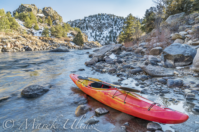
Jackson Kayak Karma RG
On my way to sand dunes I stopped at Salida to pick up this kayak from .
Karma RG is a crossover kayak designed for ocean rock gardens and river expeditions. It has a room to store my photography and camping gear. I did some tests on calm water: a cruising speed is about 4-4.5mph, so pretty fast for a whitewater boat, at least in comparison to my old Seda Cyclon. It is tracking pretty good with skeg down if wind is not too strong. Unfortunately, it’s quite heavy at 58lb. It’s a lot in comparison to my racing kayaks.
Sunset over shallow Medano Creek disappearing in sand
The Medano Creek is just disappearing in sand. This is a dead end. Let’s see some other places tomorrow.
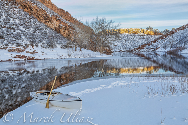
In a typical winter all lakes in northern Colorado are frozen, so I am paddling on the South Platte River. However, this winter I have not been on the river yet. All time I am paddling Sea Wind canoe on the Horsetooth Reservoir just west of Fort Collins. I didn’t paddle in January when the lake was partially frozen and there was no good access to open water.
The ice on Horsetooth is usually starting from its southern end. So, if the South Bay is covered by ice it my be still possible to launch in the north at Satanka Cove from a boat ramp or rocky tip next to the Horsetooth Dam. Sunrise Area on the eastern side would be perfect for winter launching, but is closed for a cold season. You would have to use a cart to transport boats from a parking lot down to the water or execute a pretty long portage.
Pictures below cover all my paddling from late November 2014 till late February 2015.
November 27, 2014 – Eltuck CoveDecember 9, 2014: A quiet evening near Inlet Bay.December 20, 2014 – Exploring Inlet Bay and Hansen Feeder Canal supporting water to Horsetooth Reservoir from the Colorado River through the Big Thompson Project (map)December 27, 2014 – Quarry Cove in winter scenery, my last paddling in 2014.February 4, 2015: Quarry Cove, a month later. My first paddling in 2015.February 13, 2015. Eltuck Cove. Testing a new remote control for my Canon camera – CamRanger with iPod touch.February 13, 2015: Sunset over Horsetooth Dam seen from the ELtuck Cove. Springtime weather.February 16, 2015: Back to winter weather. It was snowing. Old sandstone quarry in Satanka Cove.February 18. 2015: Quarry Cove. Some serious multitasking: paddling canoe, flying a drone and shooting selfie.
Confluence of two Grizzly Creeks 10 miles SW of Walden, CO – the beginning of the North Platte River
North Platte River is one of my favorite paddling destinations. Usually, I paddle various flatwater river sections in Wyoming above and below Saratoga. However, there is a 45 mile long river stretch in Colorado’s North Park before the North Platte enters the Northgate Canyon.
After some fall and winter scouting and a lot of time spent on Google maps, the exploration of the upper North Platte River finally took place during the Memorial Day weekend. Rob Bean joined me to paddle our inflatable Bordwarks SUPs: Shubu and Badfish.
Upper North Platte River on Google maps with some waypoints for access points and diversion dams.
14 miles of the upper North Platte River near Walden with the river beginning as a confluence of Grizzly Creek and Little Grizzly Creek
May 24, 2014 Put-in: Grizzly Creek at highway 14, 10 miles south of Walden (not much room for off road parking) Take-off: Co road 12 W, 8 miles west of Walden (official fishing access, parking near bridge, another fishing access with parking ~0.5 mile below the bridge).
GPS milege: 13.8 miles, time: 2:50 hours.
31 miles of the North Platte River from Walden to the Northgate Canyon put-in
May 25, 2014 Put-in: Co road 12 W Take-off: put-in for the Northgate Canyon run, 9 miles north of Cowdrey
Alternative put-in for a short 6 miles run: Co Rd 6, 2 miles west of Cowdrey (that run is described in Paddling Colorado book by Dunbar Hardy).
GPS milege: 31 miles, time: 6:49 hours.
River flow was rising from 3000 to 4000 cfs at Northgate during our two days of paddling. A lot of meadows in the river valley were flooded. Paddling speed: up to 9 mph.
The weather was challenging. We had a lot of thunderstorms around us during the first day followed by ~8 hours of heavy rain. We were lucky to finished our paddling before the rain. A beautiful weather on second day lasted till noon, then we experienced a storm with a small hail followed by heavy rain for the rest of the day. Strong afternoon headwinds put us on our knees, especially, during the second day.
Obstacles: diversion dams, fences across the river, low bridges depending a water level. No trees. No rapids (except dams). The river is wide and open, so you can see or hear all incoming obstacles well in advance. We never run into any troubles.
Most of the dams can be seen on satellite pictures. The dam a few miles below Co road 12 W is pretty big and always requires portaging (not comfortable on right). Other dams are primitive rock dams and often can be run. We portaged most of them to avoid big waves, but I would run more of them in a canoe. We managed to paddle around a few of them. It is easier to select a correct river arm on a map than in practice on the river.
We had to portage numerous barbed wire fences crossing the river. Some were in water and could be safely run over in a canoe, but we played safe in out inflatable SUPs. A few fences had only a single wire across the river and was possible to paddle under them. Always watch for these fences! You can notice stronger and taller posts on the shores and, sometimes, stairs over them, before seeing the actual wires over the river.
One or two low farm bridges in the upper section required portaging. All bridges in the lower section have a high clearance.
Wildlife: moose, bighorn, deer, elk (a herd was swimming across the river several times just in front of us), bald and gold eagles, pelicans, geese and other waterfowl, numerous smaller birds, curious cows.
Scenery: a wide valley surrounded by snowy mountains, crazy river meanders in the upper section, cliffs and rock outcroppings, just a few trees (often with eagle nest), higher hills with some forest in the lower section, a lot of water flowing around and flooding meadows, but, usually, not difficult to find a dry place to land.
Grizzly Creek looking upstream from highway 14Grizzly Creek looking downstream from highway 14 – start of our adventureNorth Platte River meandering near WaldenOne of high cliffsGoing over a low farm bridgeOne of diversion damsNorth Platte River at Co Rd 12 W near Walden – the finish of day 1 and the start of day 2Barbed wire fence across the riverAnother fence across the riverAnd another cattle fence to portageLunch break – last minutes of nice weatherHail storm over diversion damThe last river section between Cowdrey and NorthgateFinishing in rain at the NorthgateThe last look at the river – still rainingReady to go home …
All pictures were shot with my current paddling camera on duty – Pentax Optio WG-2. I have been using waterproof Pentax Optio cameras for paddling and other outdoor activities since their first original model was released in 2005. The newest model from that series is available now as Ricoh WG-4.
August 19, 2012. Dotsero. Preparing for the start of the Colorado River Race in the upper Glenwood Canyon – 10 miles from Dotsero to Hanging Lake Trailhead. This annual race run by Jerry Nyre takes place on the 3rd Sunday of August. Camera: Pentax Optio WG2.
March 28, 2009. Sea Wind canoe in Quarry Cove of Horsetooth Reservoir. Camera: Canon 40D on a tripod.
This picture is available for purchase from Featurepics.
It was my first paddling on the Horsetooth Reservoir this year. I launched Sea Wind canoe at North Eltuck Cove from Lory State Park just dragging my boat on snow like sleds. It was similar snow scenery as four years ago when I was shooting Colorado Winter Paddling video clip. Just an easy 6 mile paddling with a long photo session at Quarry Cove.