Tag: South PLatte River

  • Paddling South Platte River from Evans to Kuner and beyond

    Paddling South Platte River from Evans to Kuner and beyond

    South Platte River paddling

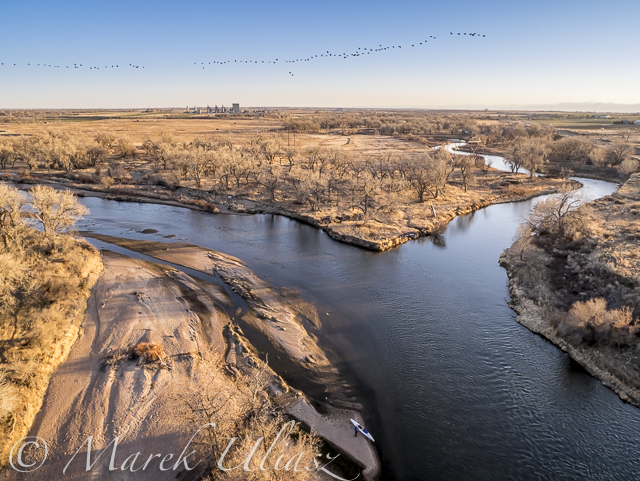
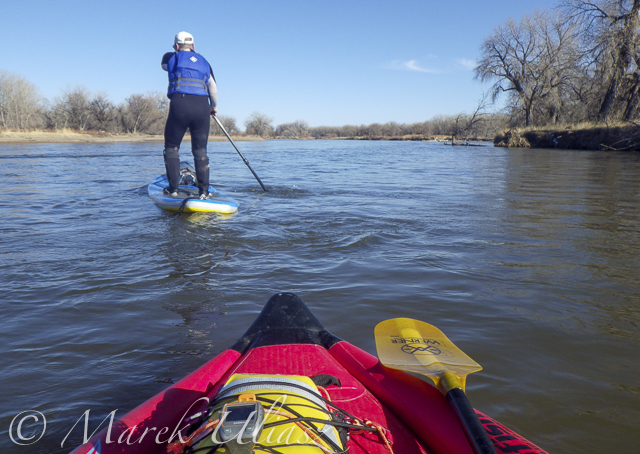
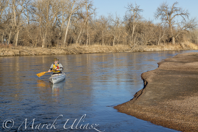
    This year Annual Joint Club Paddle returned back to a traditional section of the South Platte River on March 26th. The trip started from the Riverside Park in Evans and eded up after 9 miles at Kersey or after 15 miles at Kuner. It was a nice weather and plenty of water for paddling at ~700 cfs flow at Kersey.

    stand up paddleboards on South Platte River

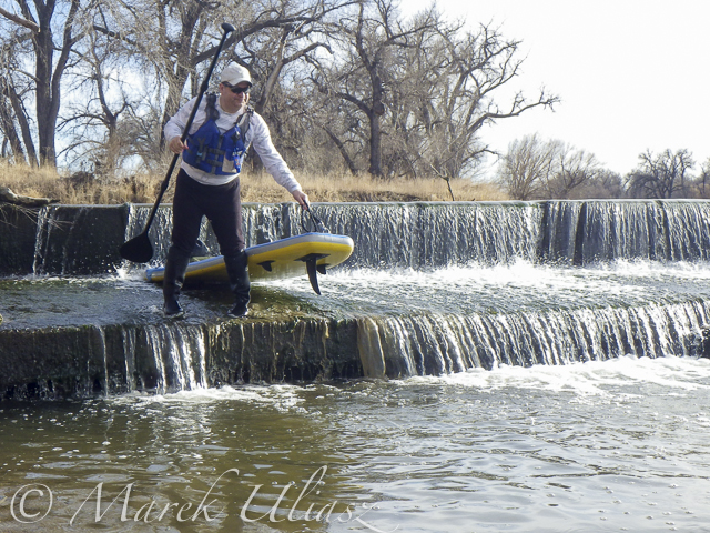
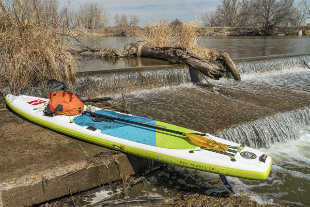
    There were 3 stand up paddleboards this year. I paddled 13.2’x30″ Voyager by Red Paddle, inflatable touring SUP with a pivoting fin by Frogfish. I paddled with the main group to the first dam, and then went a little bit faster reaching Kuner after ~3.5 hours and 15.4 miles.

    paddlers on South Platte River

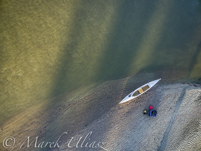
    There were some changes on the river. Portages over dams were somewhat more difficult, especially, for larger groups. The group did a longer portage over the first dam on a left shore. I managed to do a short portage portage on the right. I wanted to be on the right shore for some photography.

    SUP portage over dam

    Is it possible to paddle downriver from Kuner to Fort Morgan?

    Is it worth it?
    My answer for both questions is yes.

    10-20 years I was actively training for marathon paddle races including Texas Water Safari and WaterTribe events. It motivated me to paddle in winter and spring when lakes in northern Colorado were frozen. During that time I explored different sections of the South Platte River all the way to Fort Morgan and a little further to the Snyder bridge.

    I still have some old pictures, stories and blog posts from this series of “paddling on wet sand”, probably, with many broken links. Sorry! At least, they can give some ideas what to expect.

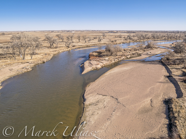
    There are numerous dams and a lot of water diversion. So, it is really necessary to check river flow data and plan accordingly. Sometimes, it may be wiser just to paddle the Evans to Kuner section with a more reliable flow. It’s better to plan shorter paddling sections or/and have some exit strategy if your paddling is going slower that expected. I paddled at flows as low as 100 cfs at Masters, but it required a lot of kayak dragging.

    Good news: some dams may be opened and runnable, especially, in winter and early spring.

    Related posts:

    My First Paddling on the South Platte River near Greeley
    New Year Paddling – 22 Miles to Fort Morgan on the South Platte River
    Paddling on Wet Sand: Discovering the South Platte River in Eastern Colorado
    Paddling on Wet Sand: the South Platte River below Fort Morgan
    30+ Miles of South Platte River in Eastern Colorado

  • Starting 2015/16 Winter Paddling Season on South Platte River

    Starting 2015/16 Winter Paddling Season on South Platte River

    A middle of November. It’s time to start my winter paddling season. Of course, Horsetooth and other local lakes in Fort Collins are still open, so I can continue my summer style paddling. Nevertheless, I took the Sea Wind canoe, Pixel (aka water Corgi) and went for the first fall/winter paddling on the South Platte River.

    We went to Masters and started to paddling upstream. However the dam just above Master bridge was closed and diverting water to Jackson Reservoir, so we paddled a couple miles downriver instead. Beautiful weather and a good flow of ~900cfs @ Weldona. Actually, I spent more time photographing than paddling.

    I am hoping to do more paddling on different sections of the South Platte River during the incoming winter season and, finally, update my river guide. Would you like to join me? The South Platte with a typical winter flow is just a wading river and suitable for safe paddling with any boat – kayak, canoe or SUP. Well, a paddleboard would require some experience and a short fin due to possible shallows. I don’t think that you need to dress for immersion, but I always take extra clothes for change.

    I am still sorting my blogs after migrating to a new server. If you encounter any problem or missing links please let me know.

    aerial view of eastern Colorado landscape with South Platte River,  water channels, reservoirs and irrigated farmland
    South Platte River in eastern Colorado below Masters with Jackson Reservoir ditch, looking downstream
    aerial view of South Platte River in eastern Colorado with a canoe on sandbar, fall scenery
    Looking down from Phantom 3 drone. Can you see the Sea Wind canoe, me and Pixel?
    aerial view of expedition decked canoe on a sandbar, South Platte River in eastern Colorado
    Let’s look a little closer
    river sandbar texture and pattern - South Platte RIver in eastern Colorado
    and, even closer
    South Platte River in eastern Colorado between Greeley and Fort Morgan, a typical fall or winter scenery
    A typical fall or winter scenery on the South Platte lit by the low setting sun
  • South Platte River from Wildcat to Evans by SUP

    South Platte River from Wildcat to Evans by SUP

    March 14, 2015. 16 miles stand up paddling (SUP) trip from Wildcat on St Vrain Creek on the South Platte River to Evans Rob Bean. Beautiful, warm weather. Numereous bald eagles, turkeys and other birds, one turtle, and surprisingly a lot of people with children playing on the river.River flow: St Vrain Cr at mouth 230 cfs, South Platte River at Fort Lupton ~350cfs. Water level on the South Platte was lower than during my last trip. Some of rocks near Wildcat Mound visible in my aerial photos were exposed. I used a short fin on my Badfish SUP and paddled without special problems, but Rob was forced to remove his regular fin in the last miles of paddling..

    We finished our trip at highway 85 bridge at Evans about 1 mile upstream from the closed Riverside Park. I was describing this place in my previous posts: comfortable parking (limited to ~10 cars) at the end of frontage road, a pretty good river access under the bridge, but the place has a lot of “urban” character (graffiti, garbage, beer bottles).

    Rob’s pictures from this paddling on facebook.

    Access to the river from the county road 19.5 looks more or less the same as before flooding. River flow ~200cfs. I started paddling trips here with flow as low as 90cfs.
    Wildcat – March 8, 2015. Access to the river from the county road 19.5 looks more or less the same as before flooding. River flow ~200cfs.
    paddling South Platte River by SUP
    Rob is paddling on St Vrain Creek just above confluence with South Platte River
    paddling South Platte River by SUP
    The first diversion dam above highway 60 bridge.
    paddling South Platte River by SUP
    Railroad trestle below highway 60 bridge.
    paddling South Platte River by SUP
    Portaging the 2nd dam. Water was low enough to just go over the dam.
    paddling South Platte River by SUP
    Landing at Evans under highway 85 bridge.
  • Paddling and Flying with Geese at St Vrain and South Platte Confluence

    Paddling and Flying with Geese at St Vrain and South Platte Confluence

    During my last paddling trip I made a stop to photograph the confluence of St Vrain Creek and South Platte River below Platteville. It was just before sunset. Hundreds of Canadian geese were passing by. I had my drone about 8 minutes in the air and some of flying geese were captured in my pictures.

    Pictures of my drone (DJI Flame Wheel F550 with Panasonic Lumix GM1 camera) were shot earlier during my first stop at Wildcat Mound about 1 mile below the confluence.

    My next visit to this river section with be probably on SUP and without the drone. I paddle Badfish SUP with a short fin which is probably safer at some shallow and rocky spots below the confluence.

    South Platte River and St Vrain
    Aerial view of the South Platte River with Sea Wind canoe and a paddler/pilot.
    South Platte River and St Vrain
    Aerial view of South Platte River and St Vrain Creek confluence looking upstream, i.e., south
    South Platte River and St Vrain
    Aerial view of South Platte River and St Vrain Creek confluence
    DJI Flame Wheel F550 drone
    DJI Flame Wheel F550 drone with Panasonic Lumix GM1 camera on a sandbar
    hexacopter drone with camera and canoe
    Sea Wind canoe with DJI Flame Wheel F550 drone

    I am adding the above pictures to Aerial Landscape gallery in my stock photography portfolio. They are available for license and immediate download as royalty free images.

    Related posts:
    Aerial View of South Platte River at Wildcat Mound below Platteville
    Paddling SUP on South Platte River from Kersey to Kuner
    South Platte River below Denver – GPS/photo river guide


  • Aerial View of South Platte River at Wildcat Mound below Platteville

    Aerial View of South Platte River at Wildcat Mound below Platteville

    A stretch of the South Platte River along Wildcat Mound below confluence with St Vrain Creek is my favorite river section for paddling. It can be accessed from the county road 19.5 bridge on the St Vrain Creek (north of the power station). This river access is relatively easy without a need to climb any fences. From here you have 1 mile of paddling to the confluence. This may be a start of a longer downriver trip or just downstream/upstream workout. The St Vrain current is pretty mild and you can easily paddle upstream. The South Platte is, in turn, much faster with some shallows and even little rock gardens (easy to navigate). It is more interesting for paddling downstream and more challenging for paddling upstream than the river section below Evans.

    During my last trip (March 10, 2015) I shot some aerial pictures of the river at Wildcat Mound from a low flying drone. This place is about 1 mile below confluence. There is a shallow rapid just below the confluence. It gave a very good workout when I was paddling back upstream. River flow was ~120 cfs at St Vrain Cr and ~400cfs on South Platte at Ft Lupton (several diversion dams upstream). For comparison you can check pictures from my packrafting trip in June, 2011. The 2013 flooding cleared all previous log jams on the St Vrain. You can still see these huge cottonwood trees in the water, but they do not block the river.

    South Platte River aerial view
    South Platte River at Wildcat Mound looking up stream
    South Platte River aerial view
    South Platte River with Sea Wind canoe
    South Platte River aerial view
    South Platte River at Wildcat Mound with a little rock garden looking down stream

    I am adding the above pictures to Aerial Landscape gallery in my stock photography portfolio. They are available for license and immediate download as royalty free images.

    Related posts:
    Paddling SUP on South Platte River from Kersey to Kuner
    Opening 2015 Paddling Season on the South Platte River
    South Platte River below Denver – GPS/photo river guide


  • Paddling SUP on South Platte River from Kersey to Kuner

    Paddling SUP on South Platte River from Kersey to Kuner

    March 8, 2015. A short, 7 mile, stand up paddling (SUP) trip on the South Platte River from Kersey to Kuner with Rob Bean and a company of goose, deer, and bald eagles. It was easy paddling with a good flow of 1100 cfs and beautiful warm weather. After, paddling I did some river scouting around Evans Riverside Park and further upstream.

    Rob’s pictures from this paddling on facebook.


    paddling SUP on South Platte River
    Launching our paddleboards below Kersey bridge next to water gauge station

    paddling SUP on South Platte River
    I paddled my Badfish SUP with a short fin and never touched the bottom. Rob paddled with a regular fin and had to step out of his board once or twice, but I believe it would be possible to avoid any shallows with a more careful navigation.
    paddling SUP on South Platte River
    Finishing our run at Kuner on left shore above the bridge
    paddling SUP on South Platte River
    A typical bridge river access on the South Platte.
    A part of Riverside Park at Evans reopened in September 2014 with entry from 42nd Street.  There is access to a small lake, but no access to the river.
    A part of Riverside Park at Evans reopened in September 2014 with entry from 42nd Street. There is access to a small lake, but no access to the river.
    Evans river access
    A bike trail going under hwy 85 bridge at Evans. Off road parking at the end of frontage road. The river access is not bad for the South Platte standards (no fences), but the under bridge scenery is pretty ugly.
    Bike trail destroyed by South Platte River flooding
    And, the bike trail ends just below the bridge. This is how probably the river shore looks further downstream at Riverside Park after the 2013 flooding.
    St Vrain Creek above  confluence with the South Platte River.
    Let’s move 16 miles upstream: St Vrain Creek at Wildcat about 1 mile before the confluence with the South Platte.
    Access to the river from the county road 19.5 looks more or less the same as before flooding. River flow ~200cfs. I started paddling trips here with flow as low as 90cfs.
    Access to the river from the county road 19.5 (no fences) looks more or less the same as before flooding. River flow ~200cfs. I have started paddling trips here with flow as low as 90cfs.
  • Opening 2015 Paddling Season on the South Platte River

    Opening 2015 Paddling Season on the South Platte River

    winter paddling on South Platte River
    Paddling Sea Wind canoe upstream of the South Platte River above Masters

    March 6, 2015. Finally, I started my 2015 paddling season on the South Platte River. I took Sea Wind canoe to Masters (about 28 miles east of Greeley on highway 34) and paddled 2.5 miles upstream and back: easy workout, a short photo session, watching bald eagles and deer.

    Masters offers a typical bridge access to the river with a barbed wire fence and wide shoulder parking. It is similar to Kuner access, perhaps a little easier and shorter. There is a diversion dam just above the bridge. It was open and easy to paddle in both directions. Several diversion dams below Kuner can be open and runnable, at least in winter. River flow was much lower (~650cfs) than at Kersey (~1000cfs), but I still had plenty of water to paddle.

    Riverside Park at Evans.The main park access from 37th Street remains closed, but the park was partially open in September 2014. Here is information from City of Evans webpage:

    On September 13, 2013, Colorado experienced widespread flood destruction from what the media referred to as “biblical” rains. Riverside Park was completely destroyed in that flood.
    One year after the flood, on September 13, 2014, the City was able to proudly open a section of the park accessible from 42nd Street. The 7-acre Riverside Lake was opened for fishing and a portion of the trail around the lake was opened as well.

    It would be worth to check if there is an easy access to the river from the reopened part of the park. Last year, I was looking for an alternative river access at Evans. There is a possibility to launch boats under the highway 85 bridge (the end of the frontage road on left shore where a bike trail starts).

    South Platte River 2 miles above Masters
    South Platte River 2 miles above Masters