Tag: St Vrain Creek

  • Winter Kayaking on the Lower St Vrain Creek

    Winter Kayaking on the Lower St Vrain Creek

    February 11, 2016. I did some scouting and a little bit of paddling on the lover St Vrain Creek.

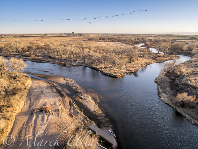
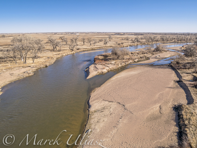
    First, I checked some potential launching spots, i.e., bridges, below I-25 highway. Then, I ended up paddling upstream from the county road 19.5 bridge (Wildcat). I use that place near St Vrain Power Station quite often, mostly as a starting point for downriver trips on the South Platte River. It was also a starting point of the 31 miles South Platte River Marathon which I tried to organize a few year ago. You can paddle 1 miles down the St Vrain to the confluence with a flow even below 100 cfs. The 7.6 miles of the river from the road 19.5 along the Wildcat Mound to highway 60 near Milliken is really scenic. I call it Wildcat Mound run in my paddling.

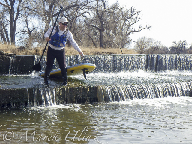
    Pictures below show the river at 150cfs. I paddled about 2 miles upstream to the diversion dam where I had a photo session. Then, after sunset, I returned back as quickly as possible since it was getting really cold. Pictures were shot with Pentax Optio WG2 camera and Sony A7R 2 on a tripod (2 last pictures).

    I paddled my old Seda Cyclone kayak in this trip. I would prefer to use another boat for an upstream/downstream workout, i.e., JKK Supernova kayak, but that little blue kayak looks better in pictures. Years ago, I did several upstream trips on the St Vrain with Sisson Nucleus kayak.

    St Vrain Creek below I-25
    St Vrain Creek below I-25 freeway (from frontage road)

    St Vrain Creek
    St Vrain Creek upstream of Colorado Blvd (county road 13)

    St Vrain Creek
    Launching my kayak under bridge of county road 19.5 (Wildcat) near St Vrain Power Plant

    Paddling upstream St Vrain Creek
    Paddling upstream

    Old trestle
    Old trestle. It could be destroyed by the recent flooding. Before the flooding, the trestle wasn’t really visible from the river.

    blue whitewater kayak and river diversion dam - St Vrain Creek near Platteville in northern Colorado
    A longer photo session with my Sony A7R 2 camera at the diversion dam

    St Vrain Creek at dusk
    After sunset … Back to my launching spot after 20 minutes of cold downriver paddling and another quick photo session.

  • South Platte River from Wildcat to Evans by SUP

    South Platte River from Wildcat to Evans by SUP

    March 14, 2015. 16 miles stand up paddling (SUP) trip from Wildcat on St Vrain Creek on the South Platte River to Evans Rob Bean. Beautiful, warm weather. Numereous bald eagles, turkeys and other birds, one turtle, and surprisingly a lot of people with children playing on the river.River flow: St Vrain Cr at mouth 230 cfs, South Platte River at Fort Lupton ~350cfs. Water level on the South Platte was lower than during my last trip. Some of rocks near Wildcat Mound visible in my aerial photos were exposed. I used a short fin on my Badfish SUP and paddled without special problems, but Rob was forced to remove his regular fin in the last miles of paddling..

    We finished our trip at highway 85 bridge at Evans about 1 mile upstream from the closed Riverside Park. I was describing this place in my previous posts: comfortable parking (limited to ~10 cars) at the end of frontage road, a pretty good river access under the bridge, but the place has a lot of “urban” character (graffiti, garbage, beer bottles).

    Rob’s pictures from this paddling on facebook.

    Access to the river from the county road 19.5 looks more or less the same as before flooding. River flow ~200cfs. I started paddling trips here with flow as low as 90cfs.
    Wildcat – March 8, 2015. Access to the river from the county road 19.5 looks more or less the same as before flooding. River flow ~200cfs.
    paddling South Platte River by SUP
    Rob is paddling on St Vrain Creek just above confluence with South Platte River
    paddling South Platte River by SUP
    The first diversion dam above highway 60 bridge.
    paddling South Platte River by SUP
    Railroad trestle below highway 60 bridge.
    paddling South Platte River by SUP
    Portaging the 2nd dam. Water was low enough to just go over the dam.
    paddling South Platte River by SUP
    Landing at Evans under highway 85 bridge.
  • Paddling and Flying with Geese at St Vrain and South Platte Confluence

    Paddling and Flying with Geese at St Vrain and South Platte Confluence

    During my last paddling trip I made a stop to photograph the confluence of St Vrain Creek and South Platte River below Platteville. It was just before sunset. Hundreds of Canadian geese were passing by. I had my drone about 8 minutes in the air and some of flying geese were captured in my pictures.

    Pictures of my drone (DJI Flame Wheel F550 with Panasonic Lumix GM1 camera) were shot earlier during my first stop at Wildcat Mound about 1 mile below the confluence.

    My next visit to this river section with be probably on SUP and without the drone. I paddle Badfish SUP with a short fin which is probably safer at some shallow and rocky spots below the confluence.

    South Platte River and St Vrain
    Aerial view of the South Platte River with Sea Wind canoe and a paddler/pilot.
    South Platte River and St Vrain
    Aerial view of South Platte River and St Vrain Creek confluence looking upstream, i.e., south
    South Platte River and St Vrain
    Aerial view of South Platte River and St Vrain Creek confluence
    DJI Flame Wheel F550 drone
    DJI Flame Wheel F550 drone with Panasonic Lumix GM1 camera on a sandbar
    hexacopter drone with camera and canoe
    Sea Wind canoe with DJI Flame Wheel F550 drone

    I am adding the above pictures to Aerial Landscape gallery in my stock photography portfolio. They are available for license and immediate download as royalty free images.

    Related posts:
    Aerial View of South Platte River at Wildcat Mound below Platteville
    Paddling SUP on South Platte River from Kersey to Kuner
    South Platte River below Denver – GPS/photo river guide


  • Aerial View of South Platte River at Wildcat Mound below Platteville

    Aerial View of South Platte River at Wildcat Mound below Platteville

    A stretch of the South Platte River along Wildcat Mound below confluence with St Vrain Creek is my favorite river section for paddling. It can be accessed from the county road 19.5 bridge on the St Vrain Creek (north of the power station). This river access is relatively easy without a need to climb any fences. From here you have 1 mile of paddling to the confluence. This may be a start of a longer downriver trip or just downstream/upstream workout. The St Vrain current is pretty mild and you can easily paddle upstream. The South Platte is, in turn, much faster with some shallows and even little rock gardens (easy to navigate). It is more interesting for paddling downstream and more challenging for paddling upstream than the river section below Evans.

    During my last trip (March 10, 2015) I shot some aerial pictures of the river at Wildcat Mound from a low flying drone. This place is about 1 mile below confluence. There is a shallow rapid just below the confluence. It gave a very good workout when I was paddling back upstream. River flow was ~120 cfs at St Vrain Cr and ~400cfs on South Platte at Ft Lupton (several diversion dams upstream). For comparison you can check pictures from my packrafting trip in June, 2011. The 2013 flooding cleared all previous log jams on the St Vrain. You can still see these huge cottonwood trees in the water, but they do not block the river.

    South Platte River aerial view
    South Platte River at Wildcat Mound looking up stream
    South Platte River aerial view
    South Platte River with Sea Wind canoe
    South Platte River aerial view
    South Platte River at Wildcat Mound with a little rock garden looking down stream

    I am adding the above pictures to Aerial Landscape gallery in my stock photography portfolio. They are available for license and immediate download as royalty free images.

    Related posts:
    Paddling SUP on South Platte River from Kersey to Kuner
    Opening 2015 Paddling Season on the South Platte River
    South Platte River below Denver – GPS/photo river guide