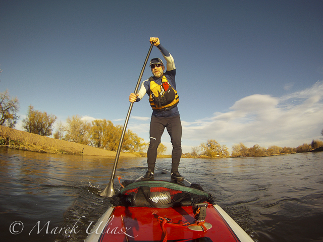
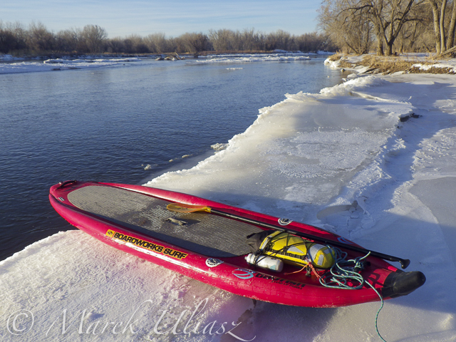
January 3, 2016. First SUP paddle of the year with Rob Bean. We paddled 10 miles on the South Platte River from highway 58 to Kuner. Great weather, river flow ~900 cfs at Kersey, several bald eagles and hundreds of ducks. There are no portages on this river section since we started just below the Plumb Ditch Dam (the second diversion dam if you paddle from Evans).
We started from a gravel bar under the new bridge on highway 58 – a right river shore with parking on a wide shoulder, a shorter, steeper route with barbed wire fence on the upstream bridge site. Downstream bridge site may be more convenient without the fence, but with a little longer walk. You can reach the bridge by turning into the new highway 49 at traffic lights from Colorado highway 34 between Evans and Kersey.
Rob posted his pictures on facebook. They actually show much better our launching site.
I am paddling 10’6″ Badfish SUP during winter on the South Platte, typically, with a shorter 2″ NRS fin.
Start at gravel bar under the new highway 58 bridgeSomewhere on the river around KerseyDucks, ducks, and more ducks. Hundreds of them.Finishing 10 mile trip at KunerA little bit icy landing at Kuner (left shore upstream of the bridge)
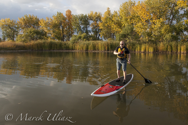
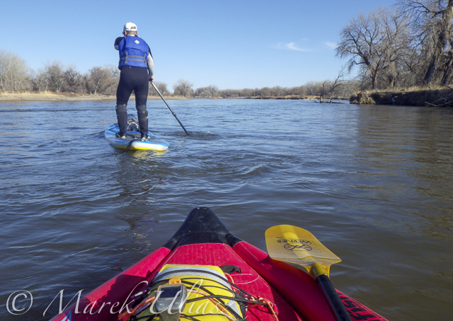
March 14, 2015. 16 miles stand up paddling (SUP) trip from Wildcat on St Vrain Creek on the South Platte River to Evans Rob Bean. Beautiful, warm weather. Numereous bald eagles, turkeys and other birds, one turtle, and surprisingly a lot of people with children playing on the river.River flow: St Vrain Cr at mouth 230 cfs, South Platte River at Fort Lupton ~350cfs. Water level on the South Platte was lower than during my last trip. Some of rocks near Wildcat Mound visible in my aerial photos were exposed. I used a short fin on my Badfish SUP and paddled without special problems, but Rob was forced to remove his regular fin in the last miles of paddling..
We finished our trip at highway 85 bridge at Evans about 1 mile upstream from the closed Riverside Park. I was describing this place in my previous posts: comfortable parking (limited to ~10 cars) at the end of frontage road, a pretty good river access under the bridge, but the place has a lot of “urban” character (graffiti, garbage, beer bottles).
Wildcat – March 8, 2015. Access to the river from the county road 19.5 looks more or less the same as before flooding. River flow ~200cfs.Rob is paddling on St Vrain Creek just above confluence with South Platte RiverThe first diversion dam above highway 60 bridge.Railroad trestle below highway 60 bridge.Portaging the 2nd dam. Water was low enough to just go over the dam.Landing at Evans under highway 85 bridge.
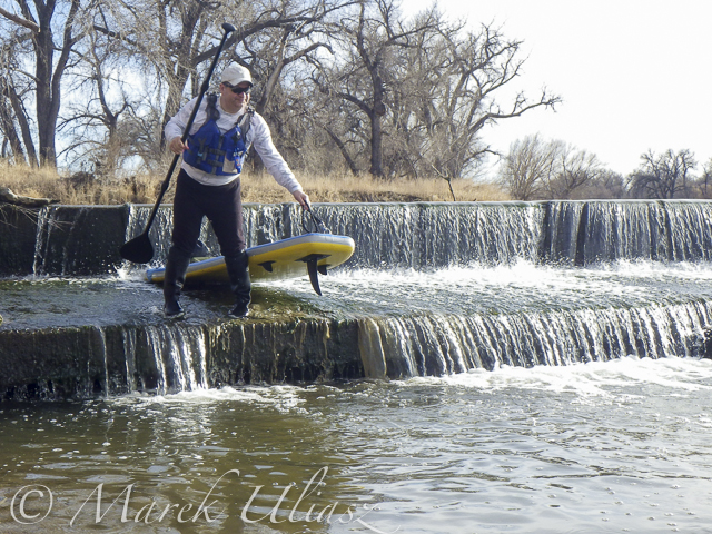
March 8, 2015. A short, 7 mile, stand up paddling (SUP) trip on the South Platte River from Kersey to Kuner with Rob Bean and a company of goose, deer, and bald eagles. It was easy paddling with a good flow of 1100 cfs and beautiful warm weather. After, paddling I did some river scouting around Evans Riverside Park and further upstream.
Launching our paddleboards below Kersey bridge next to water gauge station
I paddled my Badfish SUP with a short fin and never touched the bottom. Rob paddled with a regular fin and had to step out of his board once or twice, but I believe it would be possible to avoid any shallows with a more careful navigation.Finishing our run at Kuner on left shore above the bridgeA typical bridge river access on the South Platte.A part of Riverside Park at Evans reopened in September 2014 with entry from 42nd Street. There is access to a small lake, but no access to the river.A bike trail going under hwy 85 bridge at Evans. Off road parking at the end of frontage road. The river access is not bad for the South Platte standards (no fences), but the under bridge scenery is pretty ugly.And, the bike trail ends just below the bridge. This is how probably the river shore looks further downstream at Riverside Park after the 2013 flooding.Let’s move 16 miles upstream: St Vrain Creek at Wildcat about 1 mile before the confluence with the South Platte.Access to the river from the county road 19.5 (no fences) looks more or less the same as before flooding. River flow ~200cfs. I have started paddling trips here with flow as low as 90cfs.
Confluence of two Grizzly Creeks 10 miles SW of Walden, CO – the beginning of the North Platte River
North Platte River is one of my favorite paddling destinations. Usually, I paddle various flatwater river sections in Wyoming above and below Saratoga. However, there is a 45 mile long river stretch in Colorado’s North Park before the North Platte enters the Northgate Canyon.
After some fall and winter scouting and a lot of time spent on Google maps, the exploration of the upper North Platte River finally took place during the Memorial Day weekend. Rob Bean joined me to paddle our inflatable Bordwarks SUPs: Shubu and Badfish.
Upper North Platte River on Google maps with some waypoints for access points and diversion dams.
14 miles of the upper North Platte River near Walden with the river beginning as a confluence of Grizzly Creek and Little Grizzly Creek
May 24, 2014 Put-in: Grizzly Creek at highway 14, 10 miles south of Walden (not much room for off road parking) Take-off: Co road 12 W, 8 miles west of Walden (official fishing access, parking near bridge, another fishing access with parking ~0.5 mile below the bridge).
GPS milege: 13.8 miles, time: 2:50 hours.
31 miles of the North Platte River from Walden to the Northgate Canyon put-in
May 25, 2014 Put-in: Co road 12 W Take-off: put-in for the Northgate Canyon run, 9 miles north of Cowdrey
Alternative put-in for a short 6 miles run: Co Rd 6, 2 miles west of Cowdrey (that run is described in Paddling Colorado book by Dunbar Hardy).
GPS milege: 31 miles, time: 6:49 hours.
River flow was rising from 3000 to 4000 cfs at Northgate during our two days of paddling. A lot of meadows in the river valley were flooded. Paddling speed: up to 9 mph.
The weather was challenging. We had a lot of thunderstorms around us during the first day followed by ~8 hours of heavy rain. We were lucky to finished our paddling before the rain. A beautiful weather on second day lasted till noon, then we experienced a storm with a small hail followed by heavy rain for the rest of the day. Strong afternoon headwinds put us on our knees, especially, during the second day.
Obstacles: diversion dams, fences across the river, low bridges depending a water level. No trees. No rapids (except dams). The river is wide and open, so you can see or hear all incoming obstacles well in advance. We never run into any troubles.
Most of the dams can be seen on satellite pictures. The dam a few miles below Co road 12 W is pretty big and always requires portaging (not comfortable on right). Other dams are primitive rock dams and often can be run. We portaged most of them to avoid big waves, but I would run more of them in a canoe. We managed to paddle around a few of them. It is easier to select a correct river arm on a map than in practice on the river.
We had to portage numerous barbed wire fences crossing the river. Some were in water and could be safely run over in a canoe, but we played safe in out inflatable SUPs. A few fences had only a single wire across the river and was possible to paddle under them. Always watch for these fences! You can notice stronger and taller posts on the shores and, sometimes, stairs over them, before seeing the actual wires over the river.
One or two low farm bridges in the upper section required portaging. All bridges in the lower section have a high clearance.
Wildlife: moose, bighorn, deer, elk (a herd was swimming across the river several times just in front of us), bald and gold eagles, pelicans, geese and other waterfowl, numerous smaller birds, curious cows.
Scenery: a wide valley surrounded by snowy mountains, crazy river meanders in the upper section, cliffs and rock outcroppings, just a few trees (often with eagle nest), higher hills with some forest in the lower section, a lot of water flowing around and flooding meadows, but, usually, not difficult to find a dry place to land.
Grizzly Creek looking upstream from highway 14Grizzly Creek looking downstream from highway 14 – start of our adventureNorth Platte River meandering near WaldenOne of high cliffsGoing over a low farm bridgeOne of diversion damsNorth Platte River at Co Rd 12 W near Walden – the finish of day 1 and the start of day 2Barbed wire fence across the riverAnother fence across the riverAnd another cattle fence to portageLunch break – last minutes of nice weatherHail storm over diversion damThe last river section between Cowdrey and NorthgateFinishing in rain at the NorthgateThe last look at the river – still rainingReady to go home …
All pictures were shot with my current paddling camera on duty – Pentax Optio WG-2. I have been using waterproof Pentax Optio cameras for paddling and other outdoor activities since their first original model was released in 2005. The newest model from that series is available now as Ricoh WG-4.
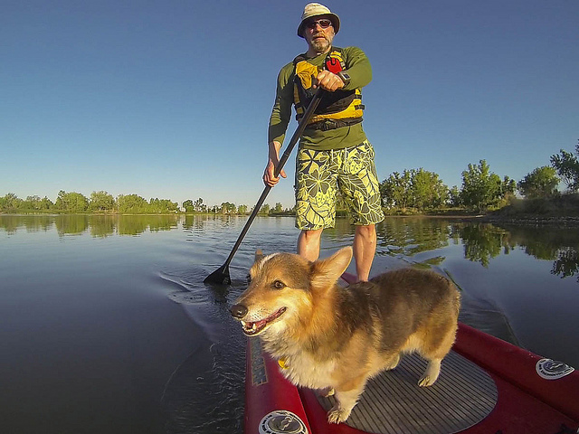
Pixel, the Corgi, grew up with Dax, the Newfoundland, and he believes that he is a water dog. He was my paddling companion in many trips taken in Sea Wind canoe. We paddled together all local lakes and several rivers including South and North Platte, Dismal, and Niobrara.
A year ago I started stand up paddling and Pixel is paddling with me on calmer lakes. He likes to ride on a stern or on a bow. Badfish SUP, a stable, whitewater board is not a challenge for him. However, a narrower and slippery Bark Expedition SUP may be more tricky and Pixel took some swims.
I’ve got a life jacket for him and we will certainly try it since water is getting cold.
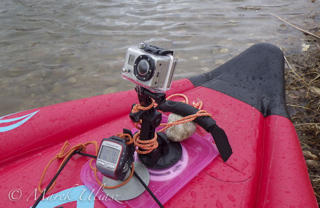
I am using suction cups on all my kayaks and canoes to mount cameras and GPS devices. Of course, you need a smooth surface to attach a suction cup. Rinsing the deck of your boat with water usually provides a stronger grip. But, what to do with decks which are not smooth like in the case of inflatable boats?
I faced that problem during my first paddling this season on Beaver Pond with Badfish inflatable SUP (stand up paddleboard). Here is my quick and temporary solution: a lid of plastic box tacked under bungees and a handle in the front deck of my SUP. It provided just enough smooth surface to place my Garmin Forerunner GPS on sticky pod suction cup and GoPro Hero camera on its original suction cup mount. My suction cup dashboard worked pretty well for quiet water paddling.
As a more permanent setup, I would probably use more a solid plate (plexiglass?) with holes to tie it to available anchor points. Do you have any other suggestions or ideas?
It was rather cold and cloudy day …
which ended up with some snow.
Two days later (March 15, 2013). Paddling Badfish SUP on Beaver Pond in Arapaho Bend Natural Area with a smoke plume from Galena wildfire behind me.
November 3, 2012. Paddling Bark Expedition SUP on the South Platte River near Kersey, Colorado. Camera: GoPro Hero.
It was my first time with SUP on a river – a short, but intense upstream / downstream workout starting at the Kersey bridge. A nice weather and good river flow. You can find more picture from that paddling in Fitness Paddling blog.
I will be back on the South Platte with SUP or other boat. The winter paddling season is open.
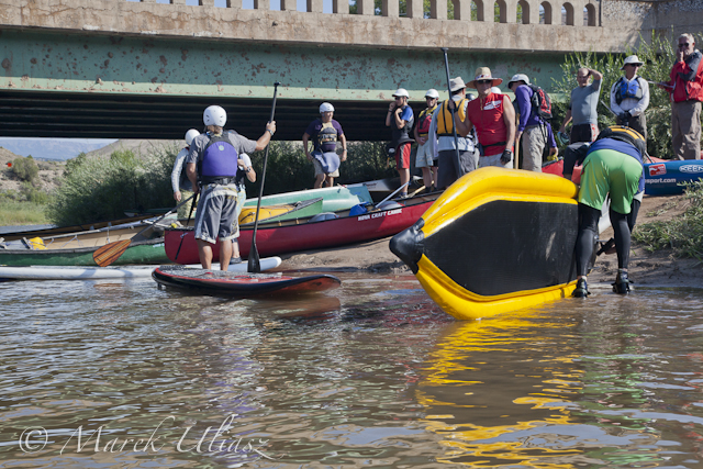
August 19, 2012. Dotsero. Preparing for the start of the Colorado River Race in the upper Glenwood Canyon – 10 miles from Dotsero to Hanging Lake Trailhead. This annual race run by Jerry Nyre takes place on the 3rd Sunday of August. Camera: Pentax Optio WG2.


 It was rather cold and cloudy day …
 which ended up with some snow.
 Two days later (March 15, 2013). Paddling Badfish SUP on Beaver Pond in Arapaho Bend Natural Area with a smoke plume from Galena wildfire behind me.