Tag: Wildcat Mound

  • Scouting the South Platte River near Greeley, Colorado

    Scouting the South Platte River near Greeley, Colorado

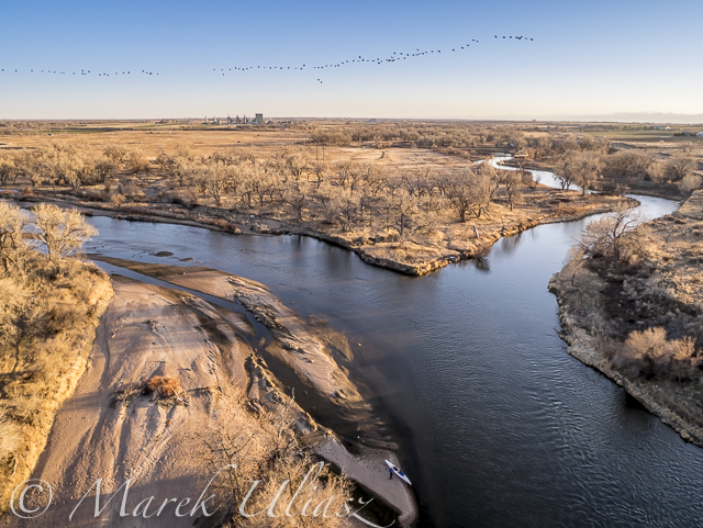
    I haven’t paddled the South Platte since the last winter, so I decided to do some scouting around Greeley. There some changes …

    Riverside Park at Evans with a river access

    Riverside Park at Evans

    The park was rebuilt after flooding damages and reopened in October of 2018. The river access requires a longer walk than it used to be, but it is more comfortable. A concrete path leads directly to a huge sandbar. No more scrambling downhill through that concrete rubbish. The parking lot is accessible only from the 37th Street in Evans. You cannot drive around ball fields as before.

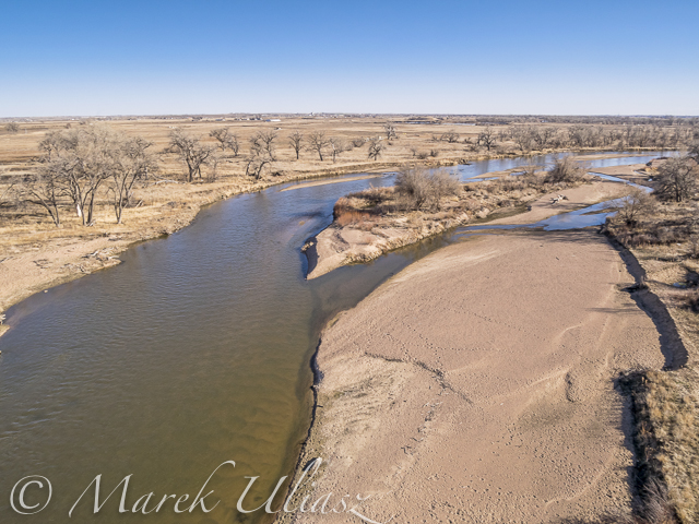
    Kersey – county road 53

    There is a construction of new bridge, so no parking along that road near the river. A little spot good for a couple of cars next to a water gage is still open. It looks like the main river channel is not obstructed, but I did not have a chance to check more carefully.

    Update: Weld County Road 53 will be closed from March 25 until April 29. The new bridge is built, and the are down to connecting the new roadway to the old roadway and then demolishing the existing bridge. I am sure it will change the river access.

    Kuner – county road 61

    It looks the same.

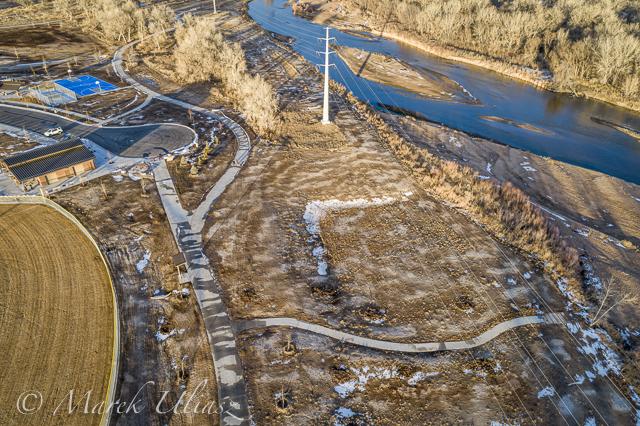
    Milliken – highway 60

    Another bridge construction. It used to be a good parking spot there with a not easy but doable river access. It’s gone now! This was the end of my favorite “Wildcat Mound” river section with a start at the lower St Vrain Creek. Of course, you can paddle further downriver to Evans, but it would be 17 instead of 7 miles with 2 additional dam portages.

    South Platte River at Evans looking downstream

    Self shuttle

    In the past, I did several river trips with a self shuttle using inline skates or bike to carry a packraft or towing a kayak. A traffic along, and, especially, across the river in Weld County has significantly increased during last a few years – a lot of farm and cistern tracks. It makes my self shuttling less attractive.

    Wildlife rangers

    In February of 2017 I had a long chat with a Weld County wildlife ranger under the Kuner bridge. I was lectured that I couldn’t legally access the river there, because the Kuner and Kersey bridges had no right off way and landowners could get upset. They also don’t allow to launch any boats from Mitani-Tokuyasu SWA above Kersey (I was using that spot 15 years or so). The ranger got some landowners complaints about trespassing, but none against paddlers. During my 20 years of paddling the South Platte I didn’t upset anybody except two wildlife rangers.

    A few years ago, a friend wanted to train with a racing canoe on the South Platte during winter, So he called Colorado Parks and Wildlife Department. He heard the same story. Yes, you can paddle the river. No, you cannot legally access the river anywhere (Kersey was specifically mentioned). However, they didn’t mentioned, that there were several public riverside parks along the South Platte below Denver including Brighton, Fort Lupton, Evans or Fort Morgan. My impression is that they really represent interests of hunters and landowners. Paddling or recreational use of the river is just a nuisance.

    I am still paddling the Horsetooth Reservoir this winter, but my first paddling on the South Platte will be the upstream/downstream workout starting at Evans Riverside Park. I am also checking water levels at St Vrain Creek.

    Related links:
    South Platte River below Denver, Colorado GPS/photo river guide (updates are required)
    South Platte River from Wildcat to Evans by SUP
    Wildcat Mound Run – the South Platte River by Bike and Packraft

  • Paddling and Flying with Geese at St Vrain and South Platte Confluence

    Paddling and Flying with Geese at St Vrain and South Platte Confluence

    During my last paddling trip I made a stop to photograph the confluence of St Vrain Creek and South Platte River below Platteville. It was just before sunset. Hundreds of Canadian geese were passing by. I had my drone about 8 minutes in the air and some of flying geese were captured in my pictures.

    Pictures of my drone (DJI Flame Wheel F550 with Panasonic Lumix GM1 camera) were shot earlier during my first stop at Wildcat Mound about 1 mile below the confluence.

    My next visit to this river section with be probably on SUP and without the drone. I paddle Badfish SUP with a short fin which is probably safer at some shallow and rocky spots below the confluence.

    South Platte River and St Vrain
    Aerial view of the South Platte River with Sea Wind canoe and a paddler/pilot.
    South Platte River and St Vrain
    Aerial view of South Platte River and St Vrain Creek confluence looking upstream, i.e., south
    South Platte River and St Vrain
    Aerial view of South Platte River and St Vrain Creek confluence
    DJI Flame Wheel F550 drone
    DJI Flame Wheel F550 drone with Panasonic Lumix GM1 camera on a sandbar
    hexacopter drone with camera and canoe
    Sea Wind canoe with DJI Flame Wheel F550 drone

    I am adding the above pictures to Aerial Landscape gallery in my stock photography portfolio. They are available for license and immediate download as royalty free images.

    Related posts:
    Aerial View of South Platte River at Wildcat Mound below Platteville
    Paddling SUP on South Platte River from Kersey to Kuner
    South Platte River below Denver – GPS/photo river guide


  • Aerial View of South Platte River at Wildcat Mound below Platteville

    Aerial View of South Platte River at Wildcat Mound below Platteville

    A stretch of the South Platte River along Wildcat Mound below confluence with St Vrain Creek is my favorite river section for paddling. It can be accessed from the county road 19.5 bridge on the St Vrain Creek (north of the power station). This river access is relatively easy without a need to climb any fences. From here you have 1 mile of paddling to the confluence. This may be a start of a longer downriver trip or just downstream/upstream workout. The St Vrain current is pretty mild and you can easily paddle upstream. The South Platte is, in turn, much faster with some shallows and even little rock gardens (easy to navigate). It is more interesting for paddling downstream and more challenging for paddling upstream than the river section below Evans.

    During my last trip (March 10, 2015) I shot some aerial pictures of the river at Wildcat Mound from a low flying drone. This place is about 1 mile below confluence. There is a shallow rapid just below the confluence. It gave a very good workout when I was paddling back upstream. River flow was ~120 cfs at St Vrain Cr and ~400cfs on South Platte at Ft Lupton (several diversion dams upstream). For comparison you can check pictures from my packrafting trip in June, 2011. The 2013 flooding cleared all previous log jams on the St Vrain. You can still see these huge cottonwood trees in the water, but they do not block the river.

    South Platte River aerial view
    South Platte River at Wildcat Mound looking up stream
    South Platte River aerial view
    South Platte River with Sea Wind canoe
    South Platte River aerial view
    South Platte River at Wildcat Mound with a little rock garden looking down stream

    I am adding the above pictures to Aerial Landscape gallery in my stock photography portfolio. They are available for license and immediate download as royalty free images.

    Related posts:
    Paddling SUP on South Platte River from Kersey to Kuner
    Opening 2015 Paddling Season on the South Platte River
    South Platte River below Denver – GPS/photo river guide