|
My local paddling lakes are frozen, but Horsetooth Reservoir is still open and the South Platter River is flowing. Unfortunately, I am not ready for my usual winter paddling yet. I need a few weeks to recover from my wrist surgery which I had just before Christmas.
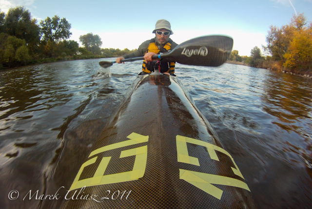
Meantime, I am reposting a photo story from my paddling on the South Platte River on January 12, 2008. I paddled Thuderbolt-x kayak upstream from Kersey to the Plumb Ditch Dam and back down the river. All pictures were shot with Pentax Optio W30. Rob Bean just paddled the same course on the South Platte with his Spencer X-treme canoe and a new wing paddle. He posted some pictures from this trip on Facebook. |
|
 |
14:00. I am launching my Thunderbolt kayak under the bridge at Kersey and starting to paddle upstream. Air temperature: a few degrees above freezing. Partially cloudy. River flow: 480 cfs. Snow on the ground and a little bit of ice along shores. There were some spectacular icicles a year ago on this shore. I have a tendency to shoot pictures at the same spots. |
 |
Passing old cars above Kersey. It is the same “parking lot” where in October 2007 I had a close meeting and a photo session with a young eagle. The river has developed some new channels during last year. |
 |
1 minute stop at the mouth of Lone Tree Creek. This time, the water level is too low to go any further. Perhaps, 50 geese were sitting there just a few seconds ago. No hunters. You wouldn’t notice this creek when paddling downstream. Paddling upstream reveals many river secrets. |
 |
Working hard upstream. Speed between 2 and 3 mph. 1 hour to confluence with the Cache la Poudre River. As expected there were some goose hunters there just packing their decoys. Mitani-Tokuyasu State Wilderness Area next to the Poudre used to be my favorite spot for kayak launching. However, nowadays, this area is open only during hunting season and a parking space is limited to 4 cars. Also, all trees on this shore died for some reason during last couple of years. |
 |
I believe that the South Platte is getting somewhat faster with more shallow spots above the confluence with the Poudre. Plumb Ditch Dam – the target of my upstream workout today. Two hours, almost 5 miles. I heard hunters somewhere near the dam, so I turned around and landed on a gravel bar a little bit further downstream. 10 minute stop. A cup of hot tea. And, easy paddling down the river back to Kersey. |
 |
Sunset. Beautiful light, but is getting cold. Brrrr! My speed down river varies between 6 and 8 mph. Of course, I am tired after upstream workout, however, I am hitting shallows more than when going slowly upstream. |
 |
Eagle tree. There were 6 bald eagles sitting on that tree. I saw many more eagles along the river. |
 |
16:50. A few minutes after sunset. I can hear the Kersey bridge. There is always a heavy and fast traffic on this road even on weekends. So, be careful during your launching operations. 9.7 miles paddled during this trip according to my GPS. |
|
Related posts: | |
Tag: winter
-
3 Winter Paddling Hours on the South Platte River
-
Are My Paddling Days Over?
I posted this little photo story in December 2006. It happens again! Beaver Pond is frozen, but Horsetooth Reservoir is still open and the South Platte River is flowing as usual.

These two have invaded my paddling zone …

… and claim that my paddling days are over.

They may be right …

for while, but …

There is still hope!

Water is flowing.Somewhere …
Some posts from winter paddling:
Winter Dusk on the South Platte River
Winter Afternoon on South Platte River with Thunderbolt-X Kayak
Winter Canoeing on the South Platte River in Northern Colorado
Climbing Snowdrifts on the South Platte River with Thunderbolt Kayak
Paddling during Duck and Goose Hunting Season on South Platte River?
My First Paddling on the South Platte River near Greeley
On the Icy South Platte River with Pentax Optio W10 Camera and Thunderbolt Kayak
Sea Wind, the Icebreaker – Paddling Video Clip from Northern Colorado
Sea Wind on the Horsetooth Reservoir – Colorado Winter Paddling Video
-
My First Paddling on the South Platte River near Greeley
I discovered the South Platte River for paddling almost 8 years ago in January 2001. I believe it was the first river I paddled in northern Colorado and, for sure, my first winter paddling here. Here is some old writing on these day trips with my CLC Patuxent 10.5 kayak. It was originally posted on Mountain Wayfarer site. At that time, I was shooting slides with Canon EOS 2AE SLR camera.
I was launching my kayak at Mitani-Tokuyasu State Wilderness Area just below the mouth of the Cache la Poudre River. This place is less suitable for paddling now days. It is open only during a hunting season and closes by the end of February. A parking space is limited to 4 cars only. See my GPS/photo river guide for other access points.

January 21st, 2001. A cold afternoon with snow clouds over entire Colorado, the last glimpse of sun. The winter of 2000/2001 is pretty cold; all my paddling lakes are frozen. The only open water I can find is the South Platte River.

I am launching my kayak at Mitani-Tokuyasu State Wilderness Area (SWA) located below Greeley, where the Cache La Poudre River joins the South Platte. This place can be reached from Highway 263 (east of Greeley) by a short stretch of bumpy road.
I’ve also explored another possible launching place: the Brower SWA, a few miles upstream – a little more difficult access to the river.

The flow is about 700 cfs and the river is shallow in wider places. The Cache La Poudre doesn’t add much water in winter, only about 70 cfs. I am paddling upstream against a pretty strong current. A little bit of snow turns this so-so river into a scenic waterway. Despite the nearby civilization and hunters, I see many birds: geese, ducks, eagles and a flock of 20-30 wild turkeys.

After about an hour and a half of paddling and perhaps 3 miles I am reaching my turning point:
a diversion dam above the 58th county road bridge. Plumb Ditch?

Resting on a small island just below the dam. Hot tea. It’s getting dark and starting to snow again. Snowflakes stick to the lens of my camera, and ice
covers the kayak deck.
Paddling against wind and snow, but down the river. It takes only 25 minutes to reach my launching spot. Paddling in a snowstorm is much more pleasant than driving in it.
It was my second kayak trip on the South Platte River. The first one took place a week earlier.
Winter conditions but no snow. I explored the river upstream and downstream of the launching place, as well as a short stretch of Cache La Poudre River.The third trip: February 11, 2001. The same route as before upstream to the diversion dam and back. Snow but sunny. A lot of hunters and shooting around but getting quiet at sunset.
I met the same turkey flock resting on a sandbar.
Related posts:
South Platte River below Denver, Colorado – GPS/photo river guide
Winter Dusk on the South Platte River
Winter Afternoon on South Platte River with Thunderbolt-X Kayak
Winter Canoeing on the South Platte River in Northern Colorado
Climbing Snowdrifts on the South Platte River with Thunderbolt Kayak
Paddling during Duck and Goose Hunting Season on South Platte River?
.
-
Winter Dusk on the South Platte River

Dusk on the South Platte River below the Plumb Ditch Dam near Greeley. Camera: Canon EOS 40D on a mini tripod. The picture was shot during a short evening paddling workout with Thunderbolt kayak starting at the Mitani-Tokuyasu State Wilderness Area (open till the end of February only) above Kersey.
Some related posts from paddling the South Platte River in winter:
- GPS Photo River Paddling Map and Guide to the South Platte Below Denver
- Winter Paddling, Training and Racing on the South Platte River in Northern Colorado
- Thunderbolt and Wildwater Racing Kayak in Training on the South Platte River
- Hunter and Prey? Looking Closer at My Paddling Pictures
- 61 Boats in the Sixth Annual South Platte River Joint Spring Paddle Trip
- Thunderbolt-X and Rapier 20 in the Upstream Race on the South Platte River
-
Paddling Sisson Nucleus on South Platte River above Evans
 A nice sunny weather and a good river flow. This time I launched my Sisson Nucleus in the afternoon at Evans River Park and paddled upstream to take a closer look at the portage over Latham Ditch Dam near La Salle. After a mile of upstream paddling I stopped under railroad bridge to take some documentary photos of an old palisade blocking passage and gathering logs and other junk. These pictures will go to my S. Platte River paddler guide. So far, I have covered about 50 continuous miles of the river from St. Vrain Creek to Masters.
The river below the dam had very little flow and was very shallow. Most of the water went right through a channel with steep banks closed by three gates. I paddled the shallow river to about 200 yards below the dam where I got finally stacked in sand. At that water level the portage was not difficult despite of some huge logs blocking access to the river. However, at higher water with flow over the dam, the landing there would be much more difficult.
I paddled about 3 miles upstream and turned around at sunset after shooting a couple of pictures. In my return way I choose different route around the dam. I paddled into channel and took off on a very steep shore between gates. Very uncomfortable at least in my tippy kayak, requiring some strength from a solo paddler, but obviously possible. It sounds like a good safari training. I did the same portage with my Spencer X-treme canoe during my birthday run down St Vrain Creek and South Platte river to Evans in April.
I finished at Evans shortly after sunset with a thin layer of ice forming on a deck of my kayak. It was nice to be able to change into dry cloths and have a cup of hot tea before driving home.
GPS trip odometer: 5.92 miles, moving time 1:49 h stopped time: 0:39 h, moving average 3.3 mph, max speed 8.5 mph. Average HRM: 131. River flow: S. Platte @ Kersey: ~850cfs. Air temperature 42-35F.


