I love paddling the South Platte River in eastern Colorado. The further downstream from Denver the better. Evans to Kersey to Kuner is a popular river segment which can be paddled year around. Below Kuner the river is getting more interesting to me, but it is more difficult to find enough water there due to numerous diversion dams. The South Platte is filling up some big reservoirs including Empire, Riverside, Jackson and North Sterling. Frequency of dams is not really higher than between Evans and Kersey, but they can take much more water.
Weather and water permitting I am going to extend my South Platte River paddling guide all the way to the Cooper Bridge below Fort Morgan. I have never managed to paddle further downstream. Every 10 miles or so the river is crossed by a highway or county road, so there are many access points. However, planning a paddling trip below Kuner requires checking flow data and some flexibility.
 …
…On February 14, 2011 I did a couple mile paddling upstream starting from Masters. You can launch under the bridge (right shore upstream) on county road 87. You need to go over a bridge rail, but not over a fence. This is a new bridge with a plenty of room for parking, In my old reports I was talking about old very narrow bridge and road.
 …
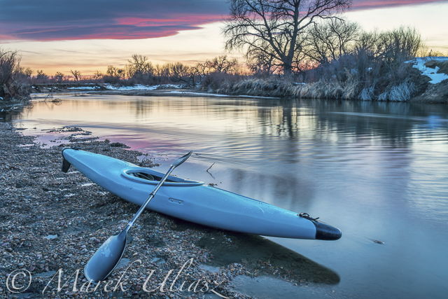
…Here, I am looking upstream from the bridge at water flow about 500 cfs. The nearest water gauge is downstream at Weldona.

The same view of the river at a lower water level, ~300 cfs at Weldona. Six year ago (February 20, 2005), I paddled my Sisson Nucleus kayak down the river from Masters to Orchard. There were sandbars everywhere and water was much clearer. Paddling was rather slow (average moving speed: 5.1 mph), but I had to walk over shallows only once or twice.
 …
… …
… …
…1/4 mile upstream of the bridge there is a diversion dam for the Jackson Reservoir canal. I believe that there is an underwater structure (gate) across the river there which can be lifted, but I have never seen it in an upright position.
 …
…Eagle nest just above the bridge. Two bald eagle couples were sitting on trees or flying in the vicinity.
Related posts:
10th Annual Spring Kickoff South Platte Paddling Trip
New Year Paddling – 22 Miles to Fort Morgan on the South Platte River
South Platte River below Denver, Colorado - GPS/photo river guide
Flow Data for South Platte River Basin in Northern and Eastern Colorado
2009 Rotten Egg Race – Results, Pictures, Handicap System
2009 South Platte River Marathon
Paddling on Wet Sand: Discovering the South Platte River in Eastern Colorado
30+ miles of South Platte River in eastern Colorado
2010 New Year Paddling – 22 Miles to Fort Morgan on the South Platte River