As a paddler I am always looking for water. Anytime! Anywhere!
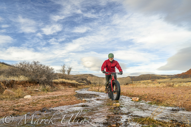
In November 2017 I made several visits to Red Mountain Open Space north of Fort Collins with my new Salsa Mukluk fat bike. I covered all possible trails. Technically, they are easy except some soft gravel and sand (many trails are going simply on dry stream beds or washes). I also did two loops in Soapstone Prairie Natural Area next door. You can check Red Mountain trails on MTB Project.
And, I’ve found some water – not enough for paddling, but plenty for my photography. Here is a little picture story which includes also some images from earlier hiking.
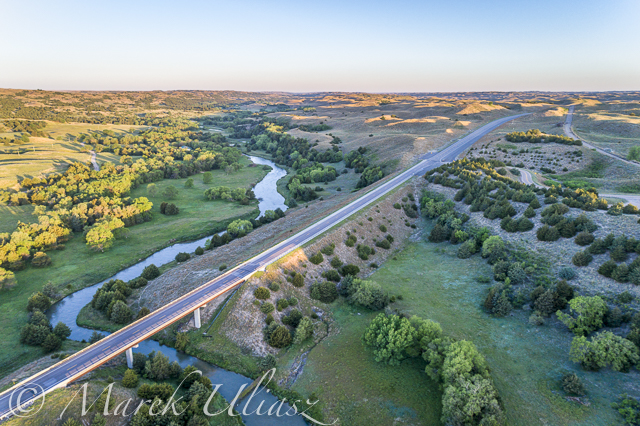
Sand Creek flows across the entire Red Mountain Open Space. You cannot ride a bike through this spectacular canyon. The Bent Rock Trail is for hiking only.Crossing the Sand Creek at high water may be a challenge, especially, along the Ruby Wash Trail where there are no stepping stones.Above the canyon, there is a little retention reservoir which turns into marsh in a dry season. Birds love it.If you ride the K-Lynn Cameron Trail you have chance to cross the Sand Creek twice and a few more times a smaller creek.Why not to ride along the creek? Well, let’s stay on the trail.It is difficult to catch water in Red Mountain in the form of snow since the area is closing for winter (December-February). I also believe that this area is getting less precipitation than Fort Collins. Anybody has some data?
In the middle of November I had patches of snow in the Ruby Wash and some drift snow along the Cheyenne Rim.My favorite drinking hole at the top of Salt Lick Trail. I just cannot pass it without shooting some pictures. A sunset photo session means a crazy ride down on soft gravel of the Ruby Wash with a falling darkness. A fat bike is doing a pretty good job in these conditions. There are more water tanks for cattle in the area which is an active open range.A little bit of liquid gold – a stream disappearing at the bottom of Ruby WashOf course, water shaped all canyons, arroyos and washes here, but that’s another story.
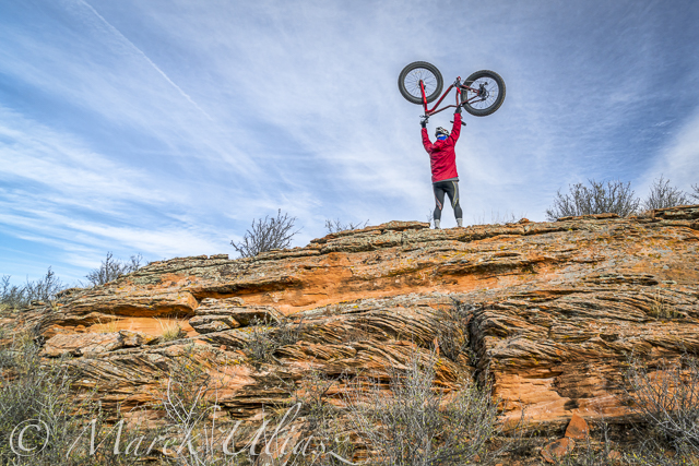
Here is my Salsa Mukluk bike on slickrock at the upper Ruby Wash
I enjoy a variety of outdoor activities. Of course, paddling in different flavors (SUP, kayak, canoe, packraft) comes first. It includes long distance racing. But, there is also biking, hiking, inline skating, drone flying and 4WD driving. The common theme here is a camera. I always have camera (or cameras) with me. It may be a small waterproof Olympus Stylus TG-5 or GoPro Hero5. Whenever possible I am hauling one of my mirrorless Sony cameras, A7R2 or A6000 with a light tripod.
After ChattaJack, my last paddling race, I shifted more towards hiking and biking. I’ve got a new toy: a fat bike, 2017 Salsa Mukluk GX1, ordered online from REI. It is my first bike with a carbon frame. As expected, it’s a lot of fun to ride that monster.
More pictures and, probably, video clips will come, but here are 10 images from my first 2 weeks of fat biking in northern Colorado. All pictures were shot with Sony A7R2 camera on a tripod.For selfies I use that camera with time lapse application.
First ride in Lory State Park – Hogback Overview trailA little weight lifting for cross trainingMahogany Loop in Soapstone Prairie Natural AreaSunset over prairie foothills from Mahogany Loop in Soapstone Prairie Natural Area.Crossing a cattle fence on Cheyenne Rim trail in Soapstone Prairie Natural Area.Patches of snow on the Cheyenne Rim in Red Mountain Open SpaceCheyenee Rim Trail requires some climbing, but offers magnificent views of the Big Hole. It is difficult to be there around sunrise or sunset for the best photography light.Ruby Wash in Red Mountain Open SpaceContemplating a tough and long ride through deep gravel on the Big Hole Wash Trail in Red Mountain Open SpaceThese fat tires really attract cactus needles …
Should I treat my tubes with Slime Sealant or just go straight for tubeless?
I have not been riding the Soapstone for a couple of years. Recently, I revisited Mahogany and Pronghorn Loops, and Cheyenne Rim Trail. There are some new features. (1) The lower, 3 mile portion of the Cheyenne Rim trail was rerouted to make room for bisons. Now, it is all a single track, a little bumpy due to rocks and cattle footprints. (2) Most of numerous gates are now equipped with cattle guards, so you don’t need to stop.
Red Mountain and Soapstone will be closed December-February, so I hope to get a few more rides there in November.
Soapstone is my favorite location for mountain biking nowadays. Red Mountain offers betters photography opportunities. I love trails in the Horsetooth area, but somehow, they became steeper and more rocky than they used to be 25 years ago …
I’ve found REI MTB Project a very useful resource for planning biking trips. I added a few pictures from my recent riding to their gallery.
Are you riding a fat bike in Fort Collins area? What are your favorite trail in northern Colorado?
After paddling a heavy expedition paddleboard in Missouri River 340 race I returned back to my racing board – 14×30 All Star by Starboard. It is definitely more fun for short 4-6 mile workouts. Of course, I wonder how my race would go in this racing board. I will be posting the race analysis in the Fitness Paddling blog.
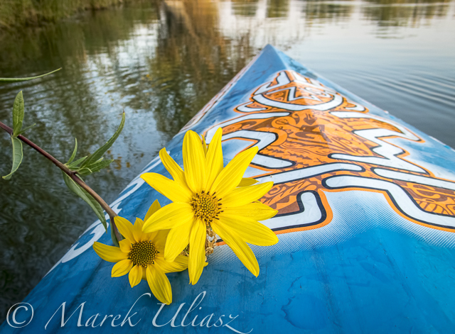
I am paddling on my local waters in Fort Collins: Horsetooth Reservoir (water level is dropping down) and Beaver Pond in Arapaho Bend Natural Area.
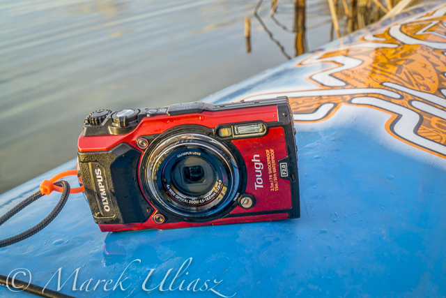
I didn’t do any serious paddling photography lately, but I always carry Olympus Stylus TG-5 waterproof camera with me. Below is another series of pictures – just trying different camera angles as a break from a paddling workout. You are welcome to check the previous posts for pictures shot around the MR340 race.
All pictures were shot in aperture mode with some exposure correction (typically somewhat underexposed). I am recording images in RAW format, and then processing them in Adobe Lightroom, and sometimes, in Photoshop if I need to remove something or apply more advanced corrections.
What camera are you using for paddling? A regular point and shoot camera, a waterproof one, GoPro Hero, a smartphone?
Sunflowers on the shore of Beaver Pond in Arapaho Bend Natural AreaSoldier Cove at Horsetooth Reservoir. You need a waterproof for this low angle shot.Another low angle shot, but at Beaver Pond in Arapaho Bend Natural Area.Just a different angle …Horsetooth Reservoir during Labor Day weekend. It was calm and quiet until sunrise. Then, I had a good training in crazy boat wakes.
Waterproof Olympus Stylus Tough TG-5 camera on a deck of All Star paddleboard.
A few weeks ago I upgraded my paddling camera to waterproof and rugged Olympus Stylus TG-5. It’s the follow-up to the Olympus STYLUS Tough TG-4and features a new sensor and processor (but reduced resolution), advanced tracking capabilities, 4K video capture, Wi-Fi.
I’ve been using waterproof cameras from Pentax Optio series for years. The last one was Pentax Optio WG-2. It was followed by Ricoh WG-30w. I understand that these cameras are now discontinued, but you can still find them or newer versions on Amazon.
My main reason to buy Olympus TG-5 camera was its ability to record images in RAW format. I like to have a full control over processing my pictures in Lightroom and/or Photoshop.
I am not often using my iPhone when paddling. Typically, the iPhone is hidden in a dry bag or I am saving its battery for communication in longer trips like MR 340 race. BTW, you can get images in RAW format from your iPhone when using the mobile Lightroom app.
You can find many reviews of the TG-5 camera online, e.g.,
New Olympus TG-5 improves ‘toughness’, brings new sensor and tracking functionality. DPreview.com.
There isn’t a better rugged waterproof compact around than the Olympus TOUGH TG-5. Like all great cameras it gets the basics right – a bright, good quality 25-100mm f2 – 4.9 lens paired with a quality 12 Megapixel sensor and high performance TruePic VIII processor. It builds on that with a great set of features and shooting modes, including Pro capture continuous shooting, 4K video, RAW support, and superb macro modes. Finally, it provides the control you need to make the most of those features, whatever the environment. The only downside is the poor performance of the movie continuous AF. CameraLabs.com
I’ve got the camera just a few days before the 12th Missouri River 340 Race (nonstop paddling race from Kansas City to St Charles). I had only time to figure out how to use aperture mode with exposure compensation and ISO adjustment. Here are some pictures shot before, during, and after the race. The pictures on the Missouri River were shot with a harsh afternoon light while other with a much nicer morning light.
Starboard Expedition 14×30 stand up paddleboard during my last training workout on Horsetooth Reservoir before MR340 race.Half underwater picture of Starboard Expedition SUP on Horsetooth Reservoir, CO.Paddle, paddle, paddle – my mantra during the race (wisdom words by Verlen Kruger).Dundee sandbar – the last rest stop before reaching race finish at St Charles – 48 miles to go.Starboard expedition with the lucky number 13 at the finish of MR340 race in St Charles, MO. I’ve been using boat number 13 in all my Texas Water Safari runs, and then the number 0013 in all 10 MR340 races.My shuttle after MR340 race; the paddleboard in at a hotel in St Charles, the car is at a hotel in Kansas City, and I am boarding Amtrak River Runner at Kirkwood, MOBack to Colorado – rinsing Missouri River mud in Horsetooth Reservoir
I believe that image quality is pretty decent, good enough to include images in my stock photography portfolio, and certainly for web publishing.
Now the big race is over. I will have some time for a more relaxed paddling and photography. I am going to compare Olympus TG-5 to my old Pentax Optio, and perhaps, to GoPro HERO camera.
I wonder if anybody is still using this type of waterproof camera for paddling and other outdoor activities in the age of a smartphone. So, what camera are you using? Please share your experience.
The Dismal River in Nebraska Sand Hills is one of my favorite paddling destination. I started paddling the Dismal in 2001 when training for Texas Water Safari. The river felt quite similar to the San Marcos River in Texas. Since then, I made several runs from Mullen to Seneca and to Thedford and one long run to Whitetail Camp in Nebraska National Forest. I always paddled Kruger’s Sea Wind canoe there.
During my recent trip to South Dakota Kayak Challenge (72 mile paddle race from Yankton to South Sioux City on the Missouri River) I crossed Nebraska twice. Both times I camped in my Toyota 4Runner on the shore of Dismal River. I used those occasions to shot some aerial pictures of the river with DJI Phantom 4 pro quadcopter.
The confluence of South and North Forks of the Dismal River below highway 97 near Mullen. It’s a launching place for kayak and canoe trips. The trail from a parking spot on the right shore to the river is very steep with a vertical drop at the end. It would be nearly impossible to return back. My aerial pictures reveal that there is rather gentle longer path to the river on the left shore.
Seneca Road bridge were most people finish their paddling. I stayed for one night there watching fire bugs. I believe that a little green meadow is a private camp (ask at Sandhills Motel at Mullen).
The Dismal meanders above highway 83 near Thedford.
The highway 83 bridge near Thedford. The good spot for landing is a little below at the old bridge. It is marked as a scenic overview.
Sand Hills above the Dismal River valley.
My old posts from paddling the Dismal River may be rather outdated, but the river character stays the same. My last paddling from Mullen to Thedford was in 2009.
Have you paddled the Dismal River lately? Any new developments or obstacles?
I started my February trip to southern Colorado with visiting Paint Mine Interpretive Park at Calhan east of Colorado Springs. I spent there evening and next morning photographing fantastic clay and sandstone erosion formations. I added some pictures to my stock photography portfolio. I am definitely going to return back to that badlands.
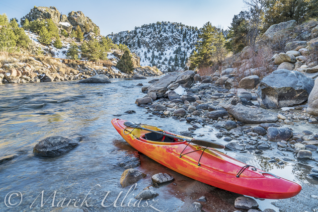
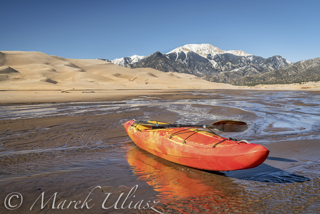
Next, I drove to Salida to pick up a new kayak, Jackson Kayak Karma RG from Colorado Kayak Supply. I was surprised by amount of water flowing in the Arkansas River. I spent afternoon and next morning at Great Sand Dunes National Park hiking and photographing. My new kayak got wet its bottom at Medano Creek.
After sand dunes I drove north back to the Arkansas River with a short side trip to Crestone. I did some shooting and a little bit of paddling at Big Bend. Then, I moved upstream to Heckla Junction. According to a ranger, the river flow was around 400cfs due to a reservoir release. I saw one raft finishing a run through Brown Canyon. I did some upstream/downstream paddling to the first rapids. I didn’t have spray skirt, otherwise I would try to push further upstream.
Since that trip, I did some paddling with Karma kayak in northern Colorado on the Horsetooth Reservoir and in a bike-paddling mode on the South Platte and St Vrain rivers.
Arkansas River at Heckla Junction
Paddling upstream Arkansas River above Hecla Junction
I paddled all winter in Fort Collins and northern Colorado: Horsetooth Reservoir, South Platte River, St Vrain Creek. One day in late February I decided to check some paddling waters in southern Colorado for a change.
Paint Mine Interpretive Park
Paint Mine Interpretive Park at Calhan, ~30 miles east of Colorado Springs, Colorado
First stop: Paint Mine. Fantastic forms of clay and sandstone erosion, canyons, hoodoos and spires. The colorful clays were used by Native Americans. Water is here sometimes, but not today except a little bit of snow. This is a great place to visit and photograph. Of course, these badlands are not for paddling. Let’s drive further south.
Great Sand Dunes National Park
Man footprints on a sand dune and blue sky in Great Sand Dunes National Park
It looks pretty dry here, but actually sand dunes in Great Sand Dunes National Park are wet. And, some of them are covered by frost on winter mornings. Yes, it can be really cold here at 7500 foot elevation.
Lost in the sea of sand – a lonely hiker in in Great Sand Dunes National Park
Water must be somewhere here. Still searching …
I used to a have a photographic obsession with sand dunes 15-20 years ago. I visited and photographed numerous sandy places in the southwest from Great Sand Dunes to Death Valley. I still have some prints of sand dunes on my walls and a collection of sand samples. That was a “Velvia” period of my photography. At that time I was shooting slides, mostly Velvia film.
Medano Creek
Sunrise over frozen Medano Creek with frosty sand dunes and Sangre De Cristo Mountains
Here it is! Unfortunately frozen. Perhaps, a little bit downstream of Medano Creek it could be better. And, maybe later in a day when it is warmer.
Meanwhile, I went for a long walk upstream of the Medano Creek.
Whitewater kayak in shallow waters of Medano Creek
There is some water flowing in the afternoon. Enough to drag a kayak and shoot some pictures, but not enough for floating. It looks like paddling on wet sand works better on the South Platte River.
Jackson Kayak Karma RG
On my way to sand dunes I stopped at Salida to pick up this kayak from .
Karma RG is a crossover kayak designed for ocean rock gardens and river expeditions. It has a room to store my photography and camping gear. I did some tests on calm water: a cruising speed is about 4-4.5mph, so pretty fast for a whitewater boat, at least in comparison to my old Seda Cyclon. It is tracking pretty good with skeg down if wind is not too strong. Unfortunately, it’s quite heavy at 58lb. It’s a lot in comparison to my racing kayaks.
Sunset over shallow Medano Creek disappearing in sand
The Medano Creek is just disappearing in sand. This is a dead end. Let’s see some other places tomorrow.
February 11, 2016. I did some scouting and a little bit of paddling on the lover St Vrain Creek.
First, I checked some potential launching spots, i.e., bridges, below I-25 highway. Then, I ended up paddling upstream from the county road 19.5 bridge (Wildcat). I use that place near St Vrain Power Station quite often, mostly as a starting point for downriver trips on the South Platte River. It was also a starting point of the 31 miles South Platte River Marathon which I tried to organize a few year ago. You can paddle 1 miles down the St Vrain to the confluence with a flow even below 100 cfs. The 7.6 miles of the river from the road 19.5 along the Wildcat Mound to highway 60 near Milliken is really scenic. I call it Wildcat Mound run in my paddling.
Pictures below show the river at 150cfs. I paddled about 2 miles upstream to the diversion dam where I had a photo session. Then, after sunset, I returned back as quickly as possible since it was getting really cold. Pictures were shot with Pentax Optio WG2 camera and Sony A7R 2 on a tripod (2 last pictures).
I paddled my old Seda Cyclone kayak in this trip. I would prefer to use another boat for an upstream/downstream workout, i.e., JKK Supernova kayak, but that little blue kayak looks better in pictures. Years ago, I did several upstream trips on the St Vrain with Sisson Nucleus kayak.
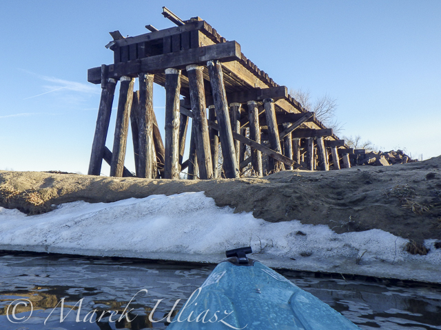
St Vrain Creek below I-25 freeway (from frontage road) St Vrain Creek upstream of Colorado Blvd (county road 13) Launching my kayak under bridge of county road 19.5 (Wildcat) near St Vrain Power Plant Paddling upstream Old trestle. It could be destroyed by the recent flooding. Before the flooding, the trestle wasn’t really visible from the river. A longer photo session with my Sony A7R 2 camera at the diversion dam After sunset … Back to my launching spot after 20 minutes of cold downriver paddling and another quick photo session.