pictures, video, stories, reviews, tips & gear for paddling photography
First, I checked some potential launching spots, i.e., bridges, below I-25 highway. Then, I ended up paddling upstream from the county road 19.5 bridge (Wildcat). I use that place near St Vrain Power Station quite often, mostly as a starting point for downriver trips on the South Platte River. It was also a starting point of the 31 miles South Platte River Marathon which I tried to organize a few year ago. You can paddle 1 miles down the St Vrain to the confluence with a flow even below 100 cfs. The 7.6 miles of the river from the road 19.5 along the Wildcat Mound to highway 60 near Milliken is really scenic. I call it Wildcat Mound run in my paddling.
Pictures below show the river at 150cfs. I paddled about 2 miles upstream to the diversion dam where I had a photo session. Then, after sunset, I returned back as quickly as possible since it was getting really cold. Pictures were shot with Pentax Optio WG2 camera and Sony A7R 2 on a tripod (2 last pictures).
I paddled my old Seda Cyclone kayak in this trip. I would prefer to use another boat for an upstream/downstream workout, i.e., JKK Supernova kayak, but that little blue kayak looks better in pictures. Years ago, I did several upstream trips on the St Vrain with Sisson Nucleus kayak.

St Vrain Creek below I-25 freeway (from frontage road)

St Vrain Creek upstream of Colorado Blvd (county road 13)

Launching my kayak under bridge of county road 19.5 (Wildcat) near St Vrain Power Plant

Paddling upstream

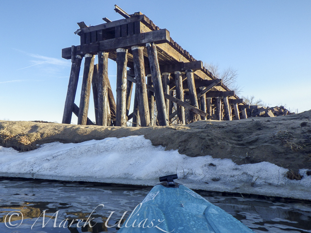
Old trestle. It could be destroyed by the recent flooding. Before the flooding, the trestle wasn’t really visible from the river.

A longer photo session with my Sony A7R 2 camera at the diversion dam

After sunset … Back to my launching spot after 20 minutes of cold downriver paddling and another quick photo session.
Recent Posts
 Train or Relax with my POV video – paddling, rowing, bikingBy Marek on June 21, 2025
 Paddling stories with my real voice vs AI voiceoverBy Marek on June 16, 2025
 Boyd Lake at dusk: bike and canoe adventureBy Marek on March 21, 2024

