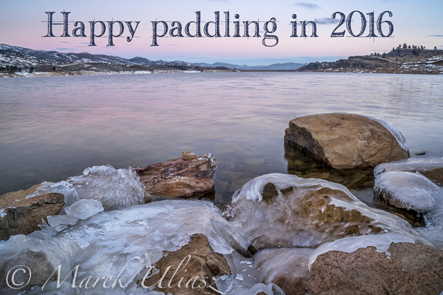
Happy New Year everybody! In the picture above: partially frozen Horsetooth Reservoir just before sunrise on December 29, 2015. Camera: Sony Alpha II with Sony/Zeiss FE 24-70mm lens on a tripod. That was a cold morning! During recent winter days in Colorado I am doing more hiking than paddling.
This is one of my new Thanksgiving greeting cards created this year. You can find more similar images with Thanksgiving, Halloween, Christmas and New Year themes in my stock photography portfolio. They available as royalty free images ready for digital download and licensing.
Selected holiday pictures are also available at FineArtAmerica. They can be ordered as fine art prints, posters, cards and other art products, e.g. iPhone cases.
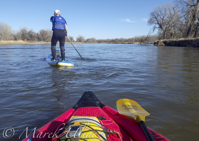
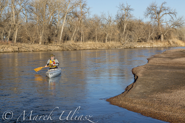
A middle of November. It’s time to start my winter paddling season. Of course, Horsetooth and other local lakes in Fort Collins are still open, so I can continue my summer style paddling. Nevertheless, I took the Sea Wind canoe, Pixel (aka water Corgi) and went for the first fall/winter paddling on the South Platte River.
We went to Masters and started to paddling upstream. However the dam just above Master bridge was closed and diverting water to Jackson Reservoir, so we paddled a couple miles downriver instead. Beautiful weather and a good flow of ~900cfs @ Weldona. Actually, I spent more time photographing than paddling.
I am hoping to do more paddling on different sections of the South Platte River during the incoming winter season and, finally, update my river guide. Would you like to join me? The South Platte with a typical winter flow is just a wading river and suitable for safe paddling with any boat – kayak, canoe or SUP. Well, a paddleboard would require some experience and a short fin due to possible shallows. I don’t think that you need to dress for immersion, but I always take extra clothes for change.
I am still sorting my blogs after migrating to a new server. If you encounter any problem or missing links please let me know.
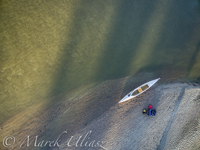
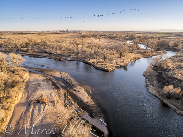
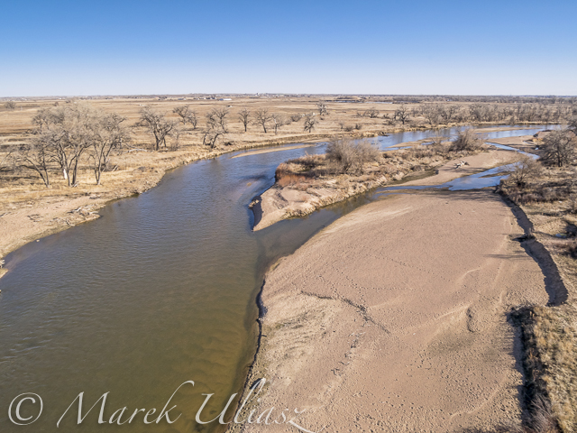
South Platte River in eastern Colorado below Masters with Jackson Reservoir ditch, looking downstreamLooking down from Phantom 3 drone. Can you see the Sea Wind canoe, me and Pixel?Let’s look a little closerand, even closerA typical fall or winter scenery on the South Platte lit by the low setting sun
I started my 2015 paddling season on Horsetooth Reservoir in early February, but my favorite time is springtime: a lot of fresh green, wild plums and other bushes in bloom, high water lever with submerged cottonwood trees and little power boat traffic. The reservoir is more than 98% full at this time (see reservoir data.
Horsetooth Reservoir is 6 miles long, but I wonder how long would be a lap around the entire lake following closely the shore. 25+ miles? There is only one way to check it out. So far this year, I haven’t paddled more than 10 miles, always in Sea Wind canoe.
There are several access spots to launch your kayak, canoe or SUP:
1. South Bay – boat ramp
2. Inlet Bay – boat ramp
3. Satanka Bay – boat ramp
4. Sunrise Area from the Centennial Road (closed during winter).
5. North Eltuck Cove from the Lory State Park (trail access up to 0.25 mile at a low water)
I am avoiding boat ramps during power boat season. Off season, I am often using one of the South Bay boat ramps. It’s possible to park on a beach close to water there. Right now, boat ramps are very short and a regular parking is really close to water. I use Sunrise Area next to swimming “beach” mostly during summer. The shore there is quite rocky and not protected from waves and boat wakes. Access point 1-4 require Larimer County Parks pass and 5 – Colorado State Park pass for your car. I used to carry my light Thunderbolt kayak from the Lory State park or tow Sea Wind on snow.
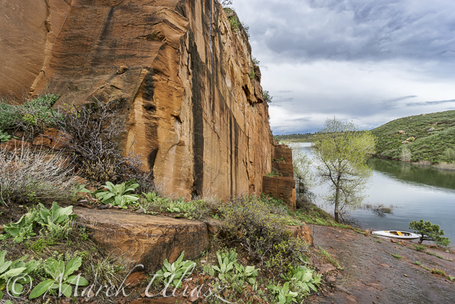
February 5, 2015: Winter dusk over Eltuck Cove looking towards Horsetooth Dam. CameraL Canon 5D M3.March 30, 2015: Aerial view of the South Eltuck Cove. Camera: Panasonic Lumix GM1 on F550 Flaming Wheel drone.April 27, 2015: Paddling north along the west coast between South Bay and Dixon Cove. Camera: Sony A6000 with 16-50mm lens.May 1, 2015: Wild plums blooming. Camera: Sony A6000 with 16-50mm lens.May 6, 2015: Old sandstone quarry in Satanka Bay. Camera: Sony A6000 with 10-18mm lens.May 6, 2015: Orchard Cove from the top of old road. Camera: Sony A6000 with 10-18mm lens.May 6, 2015: Back to sandstone cliff in Satanka Bay.
March 14, 2015. 16 miles stand up paddling (SUP) trip from Wildcat on St Vrain Creek on the South Platte River to Evans Rob Bean. Beautiful, warm weather. Numereous bald eagles, turkeys and other birds, one turtle, and surprisingly a lot of people with children playing on the river.River flow: St Vrain Cr at mouth 230 cfs, South Platte River at Fort Lupton ~350cfs. Water level on the South Platte was lower than during my last trip. Some of rocks near Wildcat Mound visible in my aerial photos were exposed. I used a short fin on my Badfish SUP and paddled without special problems, but Rob was forced to remove his regular fin in the last miles of paddling..
We finished our trip at highway 85 bridge at Evans about 1 mile upstream from the closed Riverside Park. I was describing this place in my previous posts: comfortable parking (limited to ~10 cars) at the end of frontage road, a pretty good river access under the bridge, but the place has a lot of “urban” character (graffiti, garbage, beer bottles).
Wildcat – March 8, 2015. Access to the river from the county road 19.5 looks more or less the same as before flooding. River flow ~200cfs.Rob is paddling on St Vrain Creek just above confluence with South Platte RiverThe first diversion dam above highway 60 bridge.Railroad trestle below highway 60 bridge.Portaging the 2nd dam. Water was low enough to just go over the dam.Landing at Evans under highway 85 bridge.
During my last paddling trip I made a stop to photograph the confluence of St Vrain Creek and South Platte River below Platteville. It was just before sunset. Hundreds of Canadian geese were passing by. I had my drone about 8 minutes in the air and some of flying geese were captured in my pictures.
Pictures of my drone (DJI Flame Wheel F550 with Panasonic Lumix GM1 camera) were shot earlier during my first stop at Wildcat Mound about 1 mile below the confluence.
My next visit to this river section with be probably on SUP and without the drone. I paddle Badfish SUP with a short fin which is probably safer at some shallow and rocky spots below the confluence.
Aerial view of the South Platte River with Sea Wind canoe and a paddler/pilot.Aerial view of South Platte River and St Vrain Creek confluence looking upstream, i.e., southAerial view of South Platte River and St Vrain Creek confluenceDJI Flame Wheel F550 drone with Panasonic Lumix GM1 camera on a sandbarSea Wind canoe with DJI Flame Wheel F550 drone
I am adding the above pictures to Aerial Landscape gallery in my stock photography portfolio. They are available for license and immediate download as royalty free images.
A stretch of the South Platte River along Wildcat Mound below confluence with St Vrain Creek is my favorite river section for paddling. It can be accessed from the county road 19.5 bridge on the St Vrain Creek (north of the power station). This river access is relatively easy without a need to climb any fences. From here you have 1 mile of paddling to the confluence. This may be a start of a longer downriver trip or just downstream/upstream workout. The St Vrain current is pretty mild and you can easily paddle upstream. The South Platte is, in turn, much faster with some shallows and even little rock gardens (easy to navigate). It is more interesting for paddling downstream and more challenging for paddling upstream than the river section below Evans.
During my last trip (March 10, 2015) I shot some aerial pictures of the river at Wildcat Mound from a low flying drone. This place is about 1 mile below confluence. There is a shallow rapid just below the confluence. It gave a very good workout when I was paddling back upstream. River flow was ~120 cfs at St Vrain Cr and ~400cfs on South Platte at Ft Lupton (several diversion dams upstream). For comparison you can check pictures from my packrafting trip in June, 2011. The 2013 flooding cleared all previous log jams on the St Vrain. You can still see these huge cottonwood trees in the water, but they do not block the river.
South Platte River at Wildcat Mound looking up streamSouth Platte River with Sea Wind canoeSouth Platte River at Wildcat Mound with a little rock garden looking down stream
I am adding the above pictures to Aerial Landscape gallery in my stock photography portfolio. They are available for license and immediate download as royalty free images.
March 8, 2015. A short, 7 mile, stand up paddling (SUP) trip on the South Platte River from Kersey to Kuner with Rob Bean and a company of goose, deer, and bald eagles. It was easy paddling with a good flow of 1100 cfs and beautiful warm weather. After, paddling I did some river scouting around Evans Riverside Park and further upstream.
Launching our paddleboards below Kersey bridge next to water gauge station
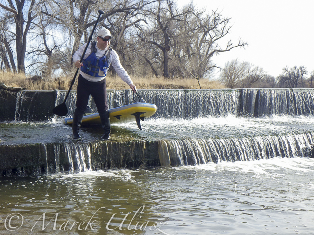
I paddled my Badfish SUP with a short fin and never touched the bottom. Rob paddled with a regular fin and had to step out of his board once or twice, but I believe it would be possible to avoid any shallows with a more careful navigation.Finishing our run at Kuner on left shore above the bridgeA typical bridge river access on the South Platte.A part of Riverside Park at Evans reopened in September 2014 with entry from 42nd Street. There is access to a small lake, but no access to the river.A bike trail going under hwy 85 bridge at Evans. Off road parking at the end of frontage road. The river access is not bad for the South Platte standards (no fences), but the under bridge scenery is pretty ugly.And, the bike trail ends just below the bridge. This is how probably the river shore looks further downstream at Riverside Park after the 2013 flooding.Let’s move 16 miles upstream: St Vrain Creek at Wildcat about 1 mile before the confluence with the South Platte.Access to the river from the county road 19.5 (no fences) looks more or less the same as before flooding. River flow ~200cfs. I have started paddling trips here with flow as low as 90cfs.
Paddling Sea Wind canoe upstream of the South Platte River above Masters
March 6, 2015. Finally, I started my 2015 paddling season on the South Platte River. I took Sea Wind canoe to Masters (about 28 miles east of Greeley on highway 34) and paddled 2.5 miles upstream and back: easy workout, a short photo session, watching bald eagles and deer.
Masters offers a typical bridge access to the river with a barbed wire fence and wide shoulder parking. It is similar to Kuner access, perhaps a little easier and shorter. There is a diversion dam just above the bridge. It was open and easy to paddle in both directions. Several diversion dams below Kuner can be open and runnable, at least in winter. River flow was much lower (~650cfs) than at Kersey (~1000cfs), but I still had plenty of water to paddle.
Riverside Park at Evans.The main park access from 37th Street remains closed, but the park was partially open in September 2014. Here is information from City of Evans webpage:
On September 13, 2013, Colorado experienced widespread flood destruction from what the media referred to as “biblical” rains. Riverside Park was completely destroyed in that flood.
One year after the flood, on September 13, 2014, the City was able to proudly open a section of the park accessible from 42nd Street. The 7-acre Riverside Lake was opened for fishing and a portion of the trail around the lake was opened as well.
It would be worth to check if there is an easy access to the river from the reopened part of the park. Last year, I was looking for an alternative river access at Evans. There is a possibility to launch boats under the highway 85 bridge (the end of the frontage road on left shore where a bike trail starts).