Author: Marek

  • Lake Superior: Journeys on an Inland Sea by Gary and Joannie McGuffin

    Lake Superior: Journeys on an Inland Sea by Gary and Joannie McGuffin

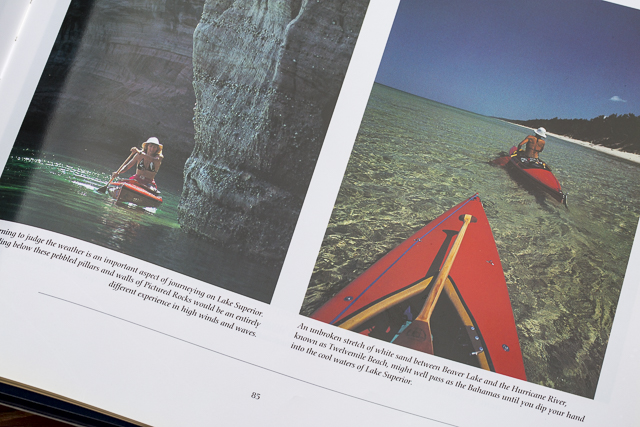
    There are several books which have influenced my paddling and photography. One of them is definitely Superior: Journeys on an Inland Sea, a wonderful coffee table book by a Canadian couple, Gary and Joanie McGuffin, full of great pictures from their kayak and canoe trips on Lake Superior.

    I believe that most of the pictures including a paddler (i.e., Joannie) were carefully staged, but they are still impressive. I am not aware of many photography books published by paddlers. Only Joel W Rogers comes to my mind.

    This in an old book. I bought it probably 20 years ago. Nowadays, you can buy used in a good condition for a few dollars. Originally, I posted this review in December of 2004.

    After getting this book I started to plan my own paddling trip on Lake Superior. It hasn’t happened yet with an exemption of a very short exploration of sea caves near Bayfield when driving back from Michigan and another short car visit in the same area. However, the book has had significant impact on my paddling.

    Lake Superior book

    I was intrigued by weird looking kayak-canoes used by McGuffins. After some research I learned about Verlen Kruger and his expedition canoes. McGuffins paddled his Monarch canoes. As a long time kayaker I wasn’t immediately convinced by Kruger’s designs, but after reading about some other long distance expeditions and e-mail exchange with Norm Miller I became a happy owner of Sea Wind canoe #127 in the summer of 2001.

    The McGuffins published several other books including Paddle Your Own Canoe, Where Rivers Run: A 6,000-Mile Exploration of Canada by Canoe, In the Footsteps of Grey Owl, Canoeing the Great Lakes Heritage Coast devoted to the 2003 expedition is also worth visiting. Again, a lot of wonderful pictures including impressive panoramas. It was example of a modern expedition combining a home built strip canoe with a high technology equipment – digital cameras, laptop and satellite communication to send updates from the trip. They also produce Wilderness Paddling calendar. It is worth to visit their web page.

  • Late Summer Stand Up Paddling with Olympus TG-5 Camera

    Late Summer Stand Up Paddling with Olympus TG-5 Camera

    After paddling a heavy expedition paddleboard in Missouri River 340 race I returned back to my racing board – 14×30 All Star by Starboard. It is definitely more fun for short 4-6 mile workouts. Of course, I wonder how my race would go in this racing board. I will be posting the race analysis in the Fitness Paddling blog.

    I am paddling on my local waters in Fort Collins: Horsetooth Reservoir (water level is dropping down) and Beaver Pond in Arapaho Bend Natural Area.

    I didn’t do any serious paddling photography lately, but I always carry Olympus Stylus TG-5 waterproof camera with me. Below is another series of pictures – just trying different camera angles as a break from a paddling workout. You are welcome to check the previous posts for pictures shot around the MR340 race.

    All pictures were shot in aperture mode with some exposure correction (typically somewhat underexposed). I am recording images in RAW format, and then processing them in Adobe Lightroom, and sometimes, in Photoshop if I need to remove something or apply more advanced corrections.

    I am adding these pictures to my stock photography portfolio.

    What camera are you using for paddling? A regular point and shoot camera, a waterproof one, GoPro Hero, a smartphone?

    stand up paddleboard and sunflowers
    Sunflowers on the shore of Beaver Pond in Arapaho Bend Natural Area
    Soldier Cove at Horsetooth Reservoir. You need a waterproof for this low angle shot.
    Another low angle shot, but at Beaver Pond in Arapaho Bend Natural Area.
    Just a different angle …
    paddleboard on Horsetooth Reservoir
    Horsetooth Reservoir during Labor Day weekend. It was calm and quiet until sunrise. Then, I had a good training in crazy boat wakes.

  • Olympus Tough TG-5 Compact Waterproof Paddling Camera

    Olympus Tough TG-5 Compact Waterproof Paddling Camera

    Waterproof Olympus Stylus Tough TG-5 camera
    Waterproof Olympus Stylus Tough TG-5 camera on a deck of All Star paddleboard.

    A few weeks ago I upgraded my paddling camera to waterproof and rugged Olympus Stylus TG-5 . It’s the follow-up to the Olympus STYLUS Tough TG-4 and features a new sensor and processor (but reduced resolution), advanced tracking capabilities, 4K video capture, Wi-Fi.

    I’ve been using waterproof cameras from Pentax Optio series for years. The last one was Pentax Optio WG-2. It was followed by Ricoh WG-30w. I understand that these cameras are now discontinued, but you can still find them or newer versions on Amazon.

    My main reason to buy Olympus TG-5 camera was its ability to record images in RAW format. I like to have a full control over processing my pictures in Lightroom and/or Photoshop.

    I am not often using my iPhone when paddling. Typically, the iPhone is hidden in a dry bag or I am saving its battery for communication in longer trips like MR 340 race. BTW, you can get images in RAW format from your iPhone when using the mobile Lightroom app.

    You can find many reviews of the TG-5 camera online, e.g.,

    New Olympus TG-5 improves ‘toughness’, brings new sensor and tracking functionality. DPreview.com.

    There isn’t a better rugged waterproof compact around than the Olympus TOUGH TG-5. Like all great cameras it gets the basics right – a bright, good quality 25-100mm f2 – 4.9 lens paired with a quality 12 Megapixel sensor and high performance TruePic VIII processor. It builds on that with a great set of features and shooting modes, including Pro capture continuous shooting, 4K video, RAW support, and superb macro modes. Finally, it provides the control you need to make the most of those features, whatever the environment. The only downside is the poor performance of the movie continuous AF. CameraLabs.com

    I’ve got the camera just a few days before the 12th Missouri River 340 Race (nonstop paddling race from Kansas City to St Charles). I had only time to figure out how to use aperture mode with exposure compensation and ISO adjustment. Here are some pictures shot before, during, and after the race. The pictures on the Missouri River were shot with a harsh afternoon light while other with a much nicer morning light.

    Half underwater picture of Starboard Expedition SUP on Horsetooth Reservoir, CO.
    Starboard Expedition 14×30 stand up paddleboard during my last training workout on Horsetooth Reservoir before MR340 race.
    Half underwater picture of Starboard Expedition SUP on Horsetooth Reservoir, CO.
    Half underwater picture of Starboard Expedition SUP on Horsetooth Reservoir, CO.
    Stand up paddleboard in Missouri RIver 340 race
    Paddle, paddle, paddle – my mantra during the race (wisdom words by Verlen Kruger).
    Stand up paddleboard in Missouri River 340 race
    Dundee sandbar – the last rest stop before reaching race finish at St Charles – 48 miles to go.
    Starboard expedition at the finish of MR340 race
    Starboard expedition with the lucky number 13 at the finish of MR340 race in St Charles, MO. I’ve been using boat number 13 in all my Texas Water Safari runs, and then the number 0013 in all 10 MR340 races.
    My shuttle after MR340 race; the paddleboard in at a hotel in St Charles, the car is at a hotel in Kansas City, and I am boarding Amtrak River Runner at Kirkwood, MO
    My shuttle after MR340 race; the paddleboard in at a hotel in St Charles, the car is at a hotel in Kansas City, and I am boarding Amtrak River Runner at Kirkwood, MO
    Back to Colorado – rinsing Missouri River mud in Horsetooth Reservoir

    I believe that image quality is pretty decent, good enough to include images in my stock photography portfolio, and certainly for web publishing.

    Now the big race is over. I will have some time for a more relaxed paddling and photography. I am going to compare Olympus TG-5 to my old Pentax Optio, and perhaps, to GoPro HERO camera.

    I wonder if anybody is still using this type of waterproof camera for paddling and other outdoor activities in the age of a smartphone. So, what camera are you using? Please share your experience.

  • Pixel, the Water Corgi, 2007-2017

    Pixel, the Water Corgi, 2007-2017

    2007: Hi, I am Pixel!

    Sea Wind canoe
    2008: Arapaho Bend Natural Area, Ft Collins, CO, Sea Wind canoe – first time in a boat

    North Platte River near Pick Bridge, WY
    2009: North Platte River near Pick Bridge, WY, Sea Wind canoe

    2009: North Platte River near Pick Bridge, WY, Sea Wind canoe

    2009: North Platte River near Pick Bridge, WY

    corgi dog
    2010:with my mother in the backyard

    Badfish SUP
    2013: Arapaho Bend Natural Area in Fort Collins. Badfish SUP

    2014: Lone Tree reservoir near Loveland, CO, Sea Wind canoe in a distorted wide angle fisheye lens perspective,

    Old Town Penobscot canoe
    2014: Arapaho Bend Natural Area, Ft Collins, CO, Old Town Penobscot canoe

    Bark Expedition SUP
    2013: Arapaho Bend Natural Area in Fort Collins. Bark Expedition SUP, after taking a swim

    Old Town Penobscot canoe
    2015: Arapaho Bend Natural Area, Ft Collins, CO, Old Town Penobscot canoe

    dog and Starboard All Star SUP on Turquoise Lake, CO
    2016: Turquoise Lake, CO, Starboard All Star racing SUP

    Related posts:
    Stand Up Paddling with Pixel, the Water Corgi
    Paddling with Pixel, the Water Corgi
    Paddling Workout with a Dog – Pixel First Time in Sea Wind Canoe
    Dismal River 2009 – Slideshow from Paddling Nebraska Sandhills
    Dax, the Newfoundland, 2002-2013

  • Dismal River in Nebraska Sand Hills from Above

    Dismal River in Nebraska Sand Hills from Above

    The Dismal River in Nebraska Sand Hills is one of my favorite paddling destination. I started paddling the Dismal in 2001 when training for Texas Water Safari. The river felt quite similar to the San Marcos River in Texas. Since then, I made several runs from Mullen to Seneca and to Thedford and one long run to Whitetail Camp in Nebraska National Forest. I always paddled Kruger’s Sea Wind canoe there.

    During my recent trip to South Dakota Kayak Challenge (72 mile paddle race from Yankton to South Sioux City on the Missouri River) I crossed Nebraska twice. Both times I camped in my Toyota 4Runner on the shore of Dismal River. I used those occasions to shot some aerial pictures of the river with DJI Phantom 4 pro quadcopter.

    Dismal River in Nebraska Sand Hills
    The confluence of South and North Forks of the Dismal River below highway 97 near Mullen. It’s a launching place for kayak and canoe trips. The trail from a parking spot on the right shore to the river is very steep with a vertical drop at the end. It would be nearly impossible to return back. My aerial pictures reveal that there is rather gentle longer path to the river on the left shore.

    Dismal River in Nebraska Sand Hills
    Seneca Road bridge were most people finish their paddling. I stayed for one night there watching fire bugs. I believe that a little green meadow is a private camp (ask at Sandhills Motel at Mullen).

    Dismal River in Nebraska Sand Hills
    The Dismal meanders above highway 83 near Thedford.

    Dismal River in Nebraska Sand Hills

    The highway 83 bridge near Thedford. The good spot for landing is a little below at the old bridge. It is marked as a scenic overview.

    Dismal River in Nebraska Sand Hills
    Sand Hills above the Dismal River valley.

    My old posts from paddling the Dismal River may be rather outdated, but the river character stays the same. My last paddling from Mullen to Thedford was in 2009.

    Have you paddled the Dismal River lately? Any new developments or obstacles?

    Related posts:
    Dismal River 2009 – Slideshow from Paddling Nebraska Sandhills
    Dismal River map with some mileage
    Dismal River – The first encounter
    Dismal River – Through barbed wire fences
    Dismal River – In November Rain

  • Searching for Paddling Water in Southern Colorado – Part 2

    Searching for Paddling Water in Southern Colorado – Part 2

    I started my February trip to southern Colorado with visiting Paint Mine Interpretive Park at Calhan east of Colorado Springs. I spent there evening and next morning photographing fantastic clay and sandstone erosion formations. I added some pictures to my stock photography portfolio. I am definitely going to return back to that badlands.

    Next, I drove to Salida to pick up a new kayak, Jackson Kayak Karma RG from Colorado Kayak Supply. I was surprised by amount of water flowing in the Arkansas River. I spent afternoon and next morning at Great Sand Dunes National Park hiking and photographing. My new kayak got wet its bottom at Medano Creek.

    After sand dunes I drove north back to the Arkansas River with a short side trip to Crestone. I did some shooting and a little bit of paddling at Big Bend. Then, I moved upstream to Heckla Junction. According to a ranger, the river flow was around 400cfs due to a reservoir release. I saw one raft finishing a run through Brown Canyon. I did some upstream/downstream paddling to the first rapids. I didn’t have spray skirt, otherwise I would try to push further upstream.

    Since that trip, I did some paddling with Karma kayak in northern Colorado on the Horsetooth Reservoir and in a bike-paddling mode on the South Platte and St Vrain rivers.

    Arkansas River at Heckla Junction
    Arkansas River at Heckla Junction

    Paddling upstream Arkansas River above Hecla Junction
    Paddling upstream Arkansas River above Hecla Junction

    Arkansas River above Hecla Junction
    Arkansas River above Hecla Junction


    Related posts:
    Searching for Paddling Water in Southern Colorado – Part 1

  • Searching for Paddling Water in Southern Colorado – Part 1

    Searching for Paddling Water in Southern Colorado – Part 1

    I paddled all winter in Fort Collins and northern Colorado: Horsetooth Reservoir, South Platte River, St Vrain Creek. One day in late February I decided to check some paddling waters in southern Colorado for a change.

    Paint Mine Interpretive Park

    Paint Mine Interpretive Park
    Paint Mine Interpretive Park at Calhan, ~30 miles east of Colorado Springs, Colorado

    First stop: Paint Mine. Fantastic forms of clay and sandstone erosion, canyons, hoodoos and spires. The colorful clays were used by Native Americans. Water is here sometimes, but not today except a little bit of snow. This is a great place to visit and photograph. Of course, these badlands are not for paddling. Let’s drive further south.

    Great Sand Dunes National Park

    footprints on sand dune
    Man footprints on a sand dune and blue sky in Great Sand Dunes National Park

    It looks pretty dry here, but actually sand dunes in Great Sand Dunes National Park are wet. And, some of them are covered by frost on winter mornings. Yes, it can be really cold here at 7500 foot elevation.

    hiker in  in Great Sand Dunes National Park
    Lost in the sea of sand – a lonely hiker in in Great Sand Dunes National Park

    Water must be somewhere here. Still searching …

    I used to a have a photographic obsession with sand dunes 15-20 years ago. I visited and photographed numerous sandy places in the southwest from Great Sand Dunes to Death Valley. I still have some prints of sand dunes on my walls and a collection of sand samples. That was a “Velvia” period of my photography. At that time I was shooting slides, mostly Velvia film.

    Medano Creek

    Medano Creek in winter
    Sunrise over frozen Medano Creek with frosty sand dunes and Sangre De Cristo Mountains

    Here it is! Unfortunately frozen. Perhaps, a little bit downstream of Medano Creek it could be better. And, maybe later in a day when it is warmer.

    Meanwhile, I went for a long walk upstream of the Medano Creek.

    Whitewater kayak in shallow waters of Medano Cree
    Whitewater kayak in shallow waters of Medano Creek

    There is some water flowing in the afternoon. Enough to drag a kayak and shoot some pictures, but not enough for floating. It looks like paddling on wet sand works better on the South Platte River.

    Jackson Kayak Karma RG

    On my way to sand dunes I stopped at Salida to pick up this kayak from .

    Karma RG is a crossover kayak designed for ocean rock gardens and river expeditions. It has a room to store my photography and camping gear. I did some tests on calm water: a cruising speed is about 4-4.5mph, so pretty fast for a whitewater boat, at least in comparison to my old Seda Cyclon. It is tracking pretty good with skeg down if wind is not too strong. Unfortunately, it’s quite heavy at 58lb. It’s a lot in comparison to my racing kayaks.

    Sunset over shallow Medano Creek
    Sunset over shallow Medano Creek disappearing in sand

    The Medano Creek is just disappearing in sand. This is a dead end. Let’s see some other places tomorrow.

  • Winter Kayaking on the Lower St Vrain Creek

    Winter Kayaking on the Lower St Vrain Creek

    February 11, 2016. I did some scouting and a little bit of paddling on the lover St Vrain Creek.

    First, I checked some potential launching spots, i.e., bridges, below I-25 highway. Then, I ended up paddling upstream from the county road 19.5 bridge (Wildcat). I use that place near St Vrain Power Station quite often, mostly as a starting point for downriver trips on the South Platte River. It was also a starting point of the 31 miles South Platte River Marathon which I tried to organize a few year ago. You can paddle 1 miles down the St Vrain to the confluence with a flow even below 100 cfs. The 7.6 miles of the river from the road 19.5 along the Wildcat Mound to highway 60 near Milliken is really scenic. I call it Wildcat Mound run in my paddling.

    Pictures below show the river at 150cfs. I paddled about 2 miles upstream to the diversion dam where I had a photo session. Then, after sunset, I returned back as quickly as possible since it was getting really cold. Pictures were shot with Pentax Optio WG2 camera and Sony A7R 2 on a tripod (2 last pictures).

    I paddled my old Seda Cyclone kayak in this trip. I would prefer to use another boat for an upstream/downstream workout, i.e., JKK Supernova kayak, but that little blue kayak looks better in pictures. Years ago, I did several upstream trips on the St Vrain with Sisson Nucleus kayak.

    St Vrain Creek below I-25
    St Vrain Creek below I-25 freeway (from frontage road)

    St Vrain Creek
    St Vrain Creek upstream of Colorado Blvd (county road 13)

    St Vrain Creek
    Launching my kayak under bridge of county road 19.5 (Wildcat) near St Vrain Power Plant

    Paddling upstream St Vrain Creek
    Paddling upstream

    Old trestle
    Old trestle. It could be destroyed by the recent flooding. Before the flooding, the trestle wasn’t really visible from the river.

    blue whitewater kayak and river diversion dam - St Vrain Creek near Platteville in northern Colorado
    A longer photo session with my Sony A7R 2 camera at the diversion dam

    St Vrain Creek at dusk
    After sunset … Back to my launching spot after 20 minutes of cold downriver paddling and another quick photo session.

  • 10 Winter Miles of Stand Up Paddling on South Platte River

    10 Winter Miles of Stand Up Paddling on South Platte River

    January 3, 2016. First SUP paddle of the year with Rob Bean. We paddled 10 miles on the South Platte River from highway 58 to Kuner. Great weather, river flow ~900 cfs at Kersey, several bald eagles and hundreds of ducks. There are no portages on this river section since we started just below the Plumb Ditch Dam (the second diversion dam if you paddle from Evans).

    We started from a gravel bar under the new bridge on highway 58 – a right river shore with parking on a wide shoulder, a shorter, steeper route with barbed wire fence on the upstream bridge site. Downstream bridge site may be more convenient without the fence, but with a little longer walk. You can reach the bridge by turning into the new highway 49 at traffic lights from Colorado highway 34 between Evans and Kersey.

    Rob posted his pictures on facebook. They actually show much better our launching site.

    I am paddling 10’6″ Badfish SUP during winter on the South Platte, typically, with a shorter 2″ NRS fin.

    Start at gravel bar under the new highway 58 bridge
    Start at gravel bar under the new highway 58 bridge

    Somewhere on the river around Kersey
    Somewhere on the river around Kersey

    Ducks, ducks, and more ducks. Hundreds of them.
    Ducks, ducks, and more ducks. Hundreds of them.

    winter SUP paddling on South Platte River
    Finishing 10 mile trip at Kuner

    A little bit icy  landing at landing (left shore upstream of the bridge)
    A little bit icy landing at Kuner (left shore upstream of the bridge)